


- 5:00 h
- 12.87 km
- 650 m
- 1,000 m
- 1,584 m
- 2,383 m
- 799 m
- Start: Lenk/Leiterli
- Destination: Lenk/Iffigenalp
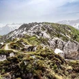
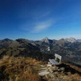
A first surprise awaits hikers at Leiterli on the Betelberg. A few meters after the signpost at the gondola station, the roughly 1 km long Leiterli Alpine flower path branches off. 95 different naturally growing alpine plants are presented here between June and October to passersby. The path later merges into the main route. On a flat path, you reach the Gumeli. Then the route changes to the south flank and passes the impressive limestone funnels of the Gryde. With a slight ascent, you reach the green ridge south of Stübleni. The view of the Lenker mountain giants directly ahead is magnificent!
Now descend over the ridge to the Stüblenipass. On an almost flat path, you reach the Äbigrat, bypassing the Fürflue. Through the east flank of the Rothorn, the route continues across the occasionally marshy area of Alp Ritzli to the Tungelpass (to Pöschenried/Färiche 1h30). The locals call the pass "Stigellegi." After the stone wall, turn left uphill into the lowest rock band of the Stigle. The path is blasted out of the rock and secured with wire ropes. Caution is still advised! On the steep north slope of the Niesehorn, you ascend sharply in a zigzag pattern. The flowers in the scree and on the rocks along the path are wonderful, and the view of the Simmental and Saanenland mountains is splendid.
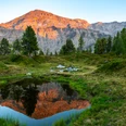
At Stigelschafberg (to the Wildhornhütte SAC 40 min, to Iffigsee via Wildhornhütte 1h10), the Iffigsee, lying 300 m below, becomes visible. You descend to it across sheep, marmot, and cattle pastures (via Iffighore–Hohberg into Groppi 2h40). Shortly after the lake, the path branches. Over the ridge of the Egge (nice viewpoint) and over Groppi, you reach the hospitable Iffigenalp on an alpine farm path.

Good to know
Pavements
Best to visit
Directions
Lenk/Leiterli - Stüblenipass - Tungelpass - Iffigsee - Lenk/Iffigenalp
Equipment
We recommend the following equipment: sturdy mountain boots, medium-sized backpack with hip belt, sun protection, rainwear, trekking poles, first aid kit, picnic, sufficient fluids, mobile phone.
Directions & Parking facilities
Outbound journey: By train via Zweisimmen to Lenk. Then by local bus or on foot to the valley station of the Betelberg gondola.
Return journey: By local bus from Iffigenalp to Lenk. Overnight guests can use the bus free of charge with the SIMMENTAL CARD.
Mountain railway timetable: More info
Local bus:Timetable
Additional information
Bernese Hiking Trails Association, Bern, Tel.: 031 340 01 01, E-mail: info@beww.ch, website: www.bernerwanderwege.ch
Literature
Hiking suggestion from the hiking book Berner Oberland, hiking book series of the Bernese hiking trails
License (master data)
Author´s Tip / Recommendation of the author
Link to the mountain guesthouse Iffigenalp: Iffigenalp.ch
Safety guidelines
This route runs entirely or partially on signposted trails of the mountain hiking trail category.
Map
swisstopo hiking map 1:50,000 263T Wildstrubel
Nearby