- 6:10 h
- 17.46 km
- 1,300 m
- 380 m
- 1,327 m
- 2,206 m
- 879 m
- Start: Münster
- Destination: Grimsel Pass
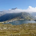
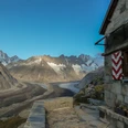
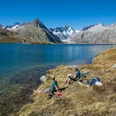
About 1000 steps separate Münster from the southern side of the valley with the young Rhone and the Rottenweg, which connects Ernen with Oberwald. 100 to 200 meters higher, the narrow forest trail stretches along the slope. On the soft ground, it feels like walking on a carpet. The clearings provide a view of the Minstigertal opposite and the villages of Münster, Geschinen, and Ulrichen, whose dark houses cluster around the white churches. West of the Ulrichen airfield, a lake stands out, created by partial removal of the runway. The excavation material was used after the 1999 avalanche winter to build the protective dam near Geschinen. In the hamlet Zum Loch, where the Ägene and Nufenen road cross, forest, Rotten and mule tracks converge and lead through a holiday settlement to Obergesteln. This place stands out with its Mediterranean architectural style strongly differing from the usual Goms village appearance. The village was rebuilt in a checkerboard stone construction style after the great fire of 1868. The old Grimsel path rises gently from the eastern edge along a small field road to the avalanche barrier at Milibach, crosses the protective dam, and after several zigzags meets the Goms high trail (point 1541). Here grazes peacefully a herd of calves and cattle whose bell ringing spreads a solemn atmosphere, supported by the church bells in the valley that now lies open and stands out favorably from the neighboring Alpine valleys due to its wide openness, loveliness, and rich greenery. The further ascent draws two loops in the even slope, which is crossed several times by an alpine road. Avalanches have stripped old trees, and now small birches and larches try to reclaim the lost ground. After Altstafel, the forest thins and the magnificent panorama with the Muttehörner, Piz Rotondo, Mittag- and Blinnenhorn becomes visible. The "paved" path sections, which have lasted for centuries, evoke admiration. Sometimes larger and sometimes smaller, flat stones are laid or set in a row to make a paving (Bikki). Chrizegge (2205 m) is the highest point of the route and the transition to the high plateau with glacially rounded rock knobs from the Ice Age. The Grimsel (2164 m) is much wilder than the Furka (2431 m) and despite the relatively low altitude gives a high alpine impression. The Totensee supposedly got its name from the dead thrown into the water after the 1799 battle between Austrians and French. However, the name is mentioned already in 1760 and perhaps refers to a lake without visible inflow or outflow.

Good to know
Pavements
Best to visit
Directions
Münster - Zum Loch - Obergesteln - Altstafel - Grimsel Pass
Equipment
We recommend the following equipment: sturdy mountain boots, medium-sized backpack with hip belt, sun protection, rainwear, hiking poles, first aid kit, picnic, enough fluids, mobile phone.
Directions & Parking facilities
Outbound: by train via Brig to Münster
Return: from Grimsel Pass by bus to Innertkirchen or Gletsch
Additional information
Bernese Hiking Trails Association, Bern, Tel.: 031 340 01 01, Email: info@beww.ch, Homepage: www.bernerwanderwege.ch
Literature
Hiking suggestion from the hiking book World Heritage Jungfrau-Aletsch-Bietschhorn, hiking book series of the Bernese Hiking Trails
License (master data)
Safety guidelines
This route runs entirely or partially on marked paths of the mountain hiking route category.
Map
Swisstopo hiking map 1:50,000 265T Nufenenpass
Nearby