


- 6:20 h
- 15.79 km
- 1,250 m
- 1,400 m
- 1,059 m
- 2,278 m
- 1,219 m
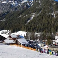
- Start: Schwenden/Grimmialp
- Destination: Achseten
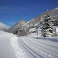
From Hotel Spillgerten on the Grimmialp (end station of the post bus route) a short distance downstream to Egg. Here the paved road turns into the valley of the Fildrich and crosses the flowery meadow slope. Soon it joins the Kileystrasse. With a moderate incline it passes the buildings of Vordere Fildrich to the magnificent hut Hindere Fildrich. Here the actual ascent begins. A forest road, later a path, winds up over the pasture ledge. The Gsür and Türmlihore rise impressively over the Chiley valley basin. The path zigzags through the steep forest slope and, at some distance, passes the uppermost hut at Mittelberg towards Oberberg. Pretty stream scenes along the way.
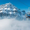
The good pass path now steadily climbs through the slope of the Wysse Flue – in early summer covered by a sea of white anemones – and turns into the high hollow of the Obertal, dominated by the Männliflue (climb 2h, only for experienced mountaineers, magnificent view). The path turns southwards to the ridge saddle between Erbithore and Wyssi Flue. From Otterepass you suddenly overlook an impressively wide ring of peaks stretching from the Wetterhorn to the Wildstrubel. Lovely view down into the green Engstligental at the feet of the dark Lohnermassiv.
Initially on a good mountain path, sometimes pathless down to the Ottere hut group, from where a rough mountain path descends over the steep, loosely wooded slope with furrows and watercourses to the meadows Im Schwand. A break for the knee joints is allowed by the flat section on an alpine road high above the Otterebach leading to Rinderwald/Eggestutz. Again the path goes steeply downhill before turning into the main valley at point 1316.
As a final, a longer stretch on asphalt awaits (shortcuts available) before reaching the bus stop in Achseten via the Höje Stäg.

Good to know
Pavements
Best to visit
Directions
Schwenden/Grimmialp - Fildrich - Otterepass - Rinderwald - Achseten
Equipment
We recommend the following equipment: sturdy mountain boots, medium-sized backpack with hip belt, sun protection, rainwear, hiking poles, first aid kit, picnic, sufficient fluids, mobile phone.
Directions & Parking facilities
Outbound journey: from Oey-Diemtigen train station by bus to Schwenden, Grimmialp
Return journey: by bus from Achseten, church
Additional information
Association Berner Wanderwege, Bern, Tel.: 031 340 01 01, E-mail: info@beww.ch, homepage: www.bernerwanderwege.ch
Literature
Hiking suggestion from the hiking book Simmental - Saanenland, hiking book series of the Berner Wanderwege
License (master data)
Safety guidelines
This route runs entirely or partially on mountain hiking trails.
Map
Swisstopo hiking map 1:50,000 263T Wildstrubel
Nearby


")
")