


- 3:30 h
- 11.30 km
- 339 m
- 101 m
- 558 m
- 798 m
- 240 m
- Start: Thun
- Destination: Sigriswil
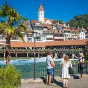
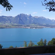
The first stage of the hike leads from the town of Thun, with its medieval castle, past idyllic places like Hünibach and Aeschlen. Shortly afterwards, the spectacular Sigriswil panorama bridge high above Lake Thun awaits to be crossed. The 340-meter-long, spectacular panorama bridge crosses the Gummi Gorge at a height of 180 meters. It is the centerpiece of the overall Panorama Route Thunersee project and connects the villages of Aeschlen and Sigriswil. Crossing the suspension bridge is subject to a fee (reduced price with guest card). The view of mountains and lake is included for free.
Stage 2 Sigriswil – Interlaken
Would you like to discover more hikes?
Learn more about the various hiking options in the Bernese Oberland.

Good to know
Pavements
Best to visit
Additional information
License (master data)
Author´s Tip / Recommendation of the author
Nearby


