- 3:30 h
- 10.17 km
- 590 m
- 650 m
- 1,042 m
- 1,569 m
- 527 m
- Start: Habkern
- Destination: Innereriz
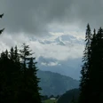
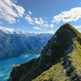
From the Habkern post office up into the hillside lane that leads high above the Lammbach valley. Past the Schützenhaus near the Bim Chrüz group of houses and the sawmill, cross the Lammgraben and turn into the valley of the Traubach. The asphalt section to be covered is compensated by rich forest flora and magnificent views. On the forest road, you climb up to a forest saddle, from where the path winds up to Trogenmoos with many loops. Here is also the border to the extensive Seefeld–Hohgant nature reserve, which with its limestone rocks, karst fields, ponds, rare shrubs, grasses, and flowers is unique. In this strange, sometimes Nordic-appearing landscape, the path turns through a rocky narrow pass to the slightly higher, forest-surrounded Grünenberg Pass. On the way, a backwards glance is worthwhile, with Finsteraarhorn, Eiger, Mönch, and Jungfrau appearing in majestic grandeur.
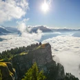
At the rest stop, enjoy a magnificent view of the forest-rich Eriz and Honegg. Soon the rough path descends in a zigzag through loosely wooded, later open slopes into the Grünenberg pasture hollow. Through the little valley of the Fallbach it leads past the Grüenenbergli hut down to Fall. Here, keep sharply to the left, cross the nearby stream, and immediately climb into the forest. Then on a good forest path down to the huts of Hindere Sol, shaded by splendid maples. A short but slippery path when wet continues downhill and joins a forest road that descends to the Fallbach. Across the meadow ground, you finally reach Innereriz/Säge, which is especially popular with nature lovers due to its beautiful location at the foot of the mighty rock bastion of Hohgant.

Good to know
Pavements
Best to visit
Directions
Equipment
We recommend the following equipment: light trekking shoes, light backpack, sun protection, rain jacket, pocket first aid kit, light picnic, plenty of fluids, mobile phone.
Directions & Parking facilities
Getting there: By train to Interlaken West. Then by bus to Habkern, Zäunli stop
Return: By STI bus from Eriz, Säge to Thun
Additional information
Literature
Hiking suggestion from the hiking book Thunersee - Frutigland, hiking book series of the Bernese Hiking Trails
License (master data)
Safety guidelines
Map
Swisstopo hiking map 1:50,000 254T Interlaken
Nearby