- 2:20 h
- 9.50 km
- 20 m
- 300 m
- 584 m
- 797 m
- 213 m
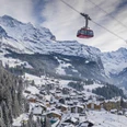
- Start: Lauterbrunnen, Station
- Destination: Wilderswil, Station
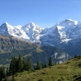
The route is signposted from the starting point at Lauterbrunnen station to the destination Wilderswil, so it is easy to find. You walk through the underpass past the parking lot and reach a footpath along the access road before the railway underpass. This leads steeply down to the white Lütschine. The route initially runs on the left, later on the right bank to the Lochbrücke. The hike along the Lütschine can be enjoyed alternately through forest or close to the river on a footpath and a driveable road. Later, you reach a former blast furnace. Iron ore mined in the rear Lauterbrunnen valley was smelted here from 1682 to 1831. A panel provides explanations, a rest area invites you to take a break. Shortly after, Zweilütschinen is reached. At the station, the tracks of the BOB / Bernese Oberland Railway and the Schwarze Lütschine must be crossed. Now a field path first descends, then ascends to the village of Gsteigwiler. On a field path, later a driveable road, it goes to the church of Gsteigwiler, which can definitely be perceived as the church of Wilderswil, so close is it to this village. The reason? As the mother church of one of the largest reformed parishes in the canton of Bern, it includes the three parishes Interlaken-Matten, Bönigen-Iseltwald and Gsteig. These include the municipalities of Gsteigwiler, Wilderswil, Gündlischwand, Lütschental and Saxteten. On a covered wooden bridge and neighborhood streets, you reach the destination of the hike at Wilderswil station.

Good to know
Pavements
Best to visit
Directions
Lauterbrunnen - Zweilütschinen - Wilderswil
Equipment
We recommend the following equipment: lightweight trekking shoes, light backpack, sun protection, rain jacket, small first aid kit, light picnic, sufficient fluids, mobile phone.
Directions & Parking facilities
Outbound: By train via Interlaken Ost to Lauterbrunnen
Return: By train from Wilderswil to Interlaken Ost and onward
Additional information
Association Bernese Hiking Trails, Bern, Tel.: 031 340 01 01, E-mail: info@beww.ch, Homepage: www.bernerwanderwege.ch
Literature
Hiking book Short hikes 2 of the Bernese hiking trails
License (master data)
Safety guidelines
This route runs exclusively on marked paths of the hiking trail category.
Map
Swisstopo Hiking Map 254T Interlaken 1:50,000
Nearby