


- 2:20 h
- 7.75 km
- 47 m
- 980 m
- 1,065 m
- 1,941 m
- 876 m
- Start: Lenk/Betelberg
- Destination: Lenk
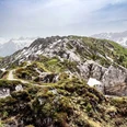
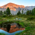
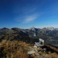
The valley station of the gondola to Betelberg is a 10-minute walk from Lenk station. Upon entering the building, you suddenly notice a distinct sulfur smell rising from a fountain by the road. This impressive olfactory blast is the result of a geological peculiarity: Lenk has the strongest sulfur springs in the Alpine region. After the ride up to Betelberg, you are immediately fascinated by the magnificent view of the Wildstrubel area, which majestically closes off the wide valley floor of the Lenk. On a wide gravel path with a pleasant gradient, you reach Stoss from the mountain station. This first part of the route is designed as the “Marmot Trail”: information boards provide children and adults with interesting facts about alpine rodents; wooden bridges and swings as well as a small zipline invite to play and discover. Several picnic places with fireplaces line the path. At the gondola mid-station Stoss, the route turns downhill, and with this the panorama changes: now the Spillgerte comes into view. On a narrow path, it goes somewhat steeper over alpine meadows and through mountain forest downwards. At the hiking trail junction in the Obere Wyssestei area, keep left and climb a few steps on the asphalt road to the Wallegg mountain lodge. From there, it goes back into the forest. Via a steep stairway, you reach the Wallbach Gorge. The water of the mountain brook thunders turbulently through whirlpools and between closely spaced, smoothly polished rock walls into the depths. Then, with only a slight gradient, it continues to Hohliebi, from there to the village center and to Lenk station.

Good to know
Pavements
Best to visit
Directions
Equipment
Directions & Parking facilities
Outbound: By train via Zweisimmen to Lenk. On foot or by local bus to the valley station of the Betelberg gondola.
Return: By train from Lenk.
Mountain railway: timetable
Additional information
Literature
Hiking suggestion from the short hikes guidebook, hiking guide series of the Bernese Hiking Trails
License (master data)
Safety guidelines
Map
swisstopo hiking map 1:50,000 263T Wildstrubel
Nearby