


- 4:50 h
- 5.96 km
- 800 m
- 800 m
- 626 m
- 1,393 m
- 767 m
- Start: Brodhüsi
- Destination: Simmeflueh
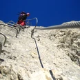
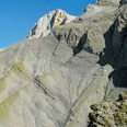
The foremost head of the Simmenfluh is called Sunnehörnli. And although the summit is only 1397 m high, the view over the entire Thun lake region is magnificent. Those who look closely will discover plenty of old iron on the well-marked route. The path was already built in 1911 when protective structures had to be erected and reforested after the great Simmenfluh fire. Since the cross-adorned Sunnehörnli found its way into various alpine and via ferrata publications a few years ago, even after new wire ropes and climbing rungs were installed, the ascent has almost become a trendy route. This, however, is completely justified, as the route follows a magnificent line through the steep rock face. A via ferrata, but an easy one: where necessary, you clip yourself into the fixed rope with a carabiner. In addition, the route is often possible very early in the year due to its southern exposure and low elevation. The descent is through the forest on the marked hiking trail.

Good to know
Pavements
Best to visit
Directions
From the parking lot steeply up through the forest to the quarry. Marked white-blue-white, alternately through steep forest sections and over rocky steep steps with wire rope protection, often exposed, to a cave at 1060 m above sea level (with seat and cave log). Further over wooded rock passages, partially secured, to the Grippelisattel and from there a simple scramble to the summit.
Descent: back to the Grippelisattel and over the north side through the steep terrain aptly called 'Shady Forest', slippery (caution when wet), down to the white-red-white marked hiking trail from Günzenen, then directly down to Brodhüsi on this trail. Or more comfortably, also white-red-white marked, on a narrow path westwards under the ridge of the Mittagflue to Chrindi, from there down to the Günzenen farm and back east along a small road until reaching the aforementioned path to Brodhüsi.
Equipment
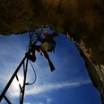
We recommend the following equipment: official via ferrata equipment, gloves, sturdy mountain boots, medium-sized backpack with hip belt, sun protection, rainwear, first aid kit, picnic, sufficient liquids, mobile phone. As well as a via ferrata set!
Directions & Parking facilities
Arrival and return: by bus from Thun to the Wimmis, Brodhüsi stop
License (master data)
Author´s Tip / Recommendation of the author
The exposed route, which is somewhat prone to rockfall, should not be underestimated and should only be undertaken in dry conditions.
Safety guidelines
According to the via ferrata scale: A to B (K1-K2, easy to moderate).
This via ferrata is often listed as very easy, which it is technically. Due to some exposed sections that are not secured, it is still not recommended for groups with beginners!
Nearby