Summit hike to the Rauflihorn

GPX

PDF

13.98 km long
Hiking Trail
Many paths lead to the Rauflihorn: from Diemtigtal there are two variants that can be combined as an circular hike and make the summit climb so worthwhile. 

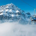
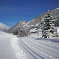
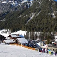
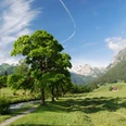
At the beginning, you hike along the Grimmimutz adventure trail through the home of the Grimmimutz forest dwarf. Although you cover a lot of altitude in a relatively short time from Nidegg, every step you take through the shady mountain forest is worthwhile: along the way you reach vantage points with beautiful views, reach a wild mountain stream waterfall and discover the red, ferruginous mineral springs of the Grimmi water. As soon as you have reached the saddle of the Grimmifurggi, you look down into the neighbouring municipality of St. Stephan and into the Färmeltal. From here follows the last ascent to the summit. Would you have expected such a view? On one side the rocky massif of the Spillgerte, on the other the vastness and width of the Diemtigtal Nature Park.

Our recommended descent takes you back along the same path to Grimmifurggi and then via Nidegg back to the starting point. Alternatively, you can also descend from the summit via Nessli to Vordere Fildrich, but there you will cross a pasture with guard dogs. 

Info

Directions

Follow the route from Senggiweid via Würzi through the forest. The mountain trail winds in many bends up to Alp Grimmi and leads through the Grimmiwasser to the Grimmifurggi pass. From here you reach the summit of the Rauflihorn in just under an hour. To avoid having to cross a pasture with guard dogs in the Nessli area, we recommend that you first take the same path back to Grimmifurggi and then walk past the mountain station of the Grimmialp cable cars via Nidegg back to the starting point.  The trail is signposted with yellow direction signs or with trail markings as a mountain trail.

You can plan your hike according to your wishes: the tour is also possible in the opposite direction. Of course, you can also take the same path twice.

Equipment

Good mountain boots, clothing appropriate to the weather (sun/rain protection), hiking poles if necessary, binoculars if necessary, pocket pharmacy, rucksack with food and enough drinks for the journey

Recommendation

If you want to shorten the ascent and descent of the hike, you can do so with the chairlift of the Grimmialp cable cars (note opening times: grimmialp.ch). 

Directions

Motorway A6 Bern direction Zweisimmen, 1 km after the Simmenfluhtunnel turn left direction Diemtigtal. Follow the Diemtigtal road into the valley for 19 km in the direction of Schwenden, Grimmialp.
Paid parking is available directly at the starting point.

Public transit

By train to Oey-Diemtigen. Then take the PostBus to the stop «Schwenden i.D., Grimmialp» (terminus). From here, a short walk (approx. 5 min.) in the direction of Grimmimutz adventure trail to Senggiweid, your starting point.

Additional information

A hiking map is available from the Diemtigtal Nature Park office.

Diemtigtal Nature Park
Bahnhofstrasse 20
3753 Oey
T 033 552 26 00
[email protected]
www.diemtigtal.ch

Nearby

tour facts
start: Senggiweid (Grimmialp), Schwenden
destination: Senggiweid (Grimmialp), Schwenden

medium

05:30:00 h

13.98 km

1,101 m

1,103 m

1,222 m

2,323 m

It appears that you are using Microsoft Internet Explorer as your web browser to access our site.

For practical and security reasons, we recommend that you use a current web browser such as Firefox, Chrome, Safari, Opera, or Edge. Internet Explorer does not always display the complete content of our website and does not offer all the necessary functions.