


- 5:00 h
- 12.37 km
- 1,100 m
- 900 m
- 1,380 m
- 2,383 m
- 1,003 m
- Start: Postbus stop Lauenensee / Legerlibrügg
- Destination: Lenk/Iffigenalp
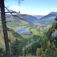
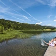
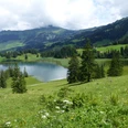
From the Postbus stop Legerlibrügg by the well-known Lauenensee, follow the hiking trail downhill along the valley to Vorsass. The path now ascends more steeply and winds in a zigzag through the rock bands of Holzersflue up to Alp Chüetungel (via Burgbüel to Stigelschafberg, point 2300, 1h30; caution in the rock bands of the Stigle!). Over the steeply sloping slope of Holzersflue, it then mostly ascends pathlessly to the hut and then makes a large arc through the wide Alp Stieretungel. On an almost level path, passing a distinctive flat moor, you reach the Tungelpass (via Stigelberg to Pöschenried/Färiche 2h). A stone wall here marks the border between the administrative districts of Saanen and Obersimmental. The people from Lenk call the pass "Stigellegi." The 700 m high wall of the Niesehorn towers impressively. Head straight for this and enter the lowest band of the Stigle. The path is cut into the rocks and secured with wire cables. Caution is still advised! The path zigzags up to Stigelschafberg. The flowers in the scree and rocks along the path are beautiful. Through a rocky hollow, it goes to the highest point of the hike at 2381 m (to Wildhornhütte SAC 45 min). Now the Iffigsee, about 300 m lower, becomes visible, to which you descend over sheep, marmot, and cattle pastures. Shortly after the lake end, the path branches. The more pleasant variant leads past a pond over the scenic ridge down to Groppi and along an alpine road in the valley bottom to the hospitable Iffigenalp.

Good to know
Pavements
Best to visit
Directions
Equipment
Directions & Parking facilities
Outbound: By train via Zweisimmen to Gstaad. Then by bus to Lauenensee (final stop Legerlibrügg)
Return: By bus from Iffigenalp to Lenk. Then by train
Additional information
Literature
Hiking suggestion from the hiking book Simmental - Saanenland, hiking book series of the Bernese Hiking Trails
License (master data)
Safety guidelines
This route runs entirely or partially on marked trails of the mountain hiking trail category.
Map
Swisstopo hiking map 1:50,000 263T Wildstrubel
Nearby