


- 6:20 h
- 16.01 km
- 889 m
- 1,123 m
- 1,042 m
- 2,135 m
- 1,093 m
- Start: Harderkulm
- Destination: Habkern
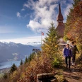
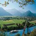
From the top station of the Harderbahn, the path goes to the Harderkulm restaurant and immediately climbs steeply eastwards into the magnificent mountain forest. The path now alternately runs along the south slope of the Harder, then back along the ridge height. In zigzag it goes up to the Wannichnubel, which is passed to the south. Repeatedly delightful views from the forest into the Habkern valley, to the Niesen range, and Thunersee. Deep below lie Ringgenberg with the Burgseeli and at the end of Brienzersee Bönigen. Unexpectedly, you stand before the Roteflue (to Ringgenberg 2h10, very steep descent!). At the Alp Horet, the forest remains behind (to Habkern 1h30). The footpath mostly leads over the ridge height to Horetegg, which offers a magnificent panoramic view. For the ascent to the Tritt (to Niederried 3h10, very steep!) and over the Suggiture further to Augstmatthorn, one uses the clearly visible ridge path. On the bands and cliff tops of the ridge flank, the here numerous Alpine ibex gather.
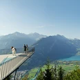
The view from Augstmatthorn is magnificent: deep below lies the Brienzersee. Behind, the Schynige Platte-Faulhorn chain rises, and above shine the peaks of the Alps. To the north, the view goes to Hohgant and into the catchment area of the Emme, while to the west Güggisgrat and Solflue border the Habkern valley basin.
Initially extraordinarily steep, the path winds in a zigzag down an alpine ridge into the valley. At the Lombachalp parking lot, you reach the asphalt road, which you follow for a few minutes. Then a path turns into the meadowslope, which, with moderate gradient, leads over Schwendallmi to the Bol bridge below Bolsiten and to Habkern.
Please observe the following rules of conduct

Good to know
Pavements
Best to visit
Directions
Harderkulm - Horetegg - Augstmatthorn - Lombachalp - Habkern
Equipment
We recommend the following equipment: sturdy hiking boots, medium-sized backpack with hip belt, sun protection, rainwear, trekking poles, first aid kit, picnic, sufficient liquids, mobile phone.
Directions & Parking facilities
Outbound: By train to Interlaken Ost. On foot to the valley station of the Harderbahn (10 min).
Return: By bus from Habkern, Post to Interlaken West.
Additional information
Association Bernese Hiking Trails, Bern, Tel.: 031 340 01 01, E-mail: info@beww.ch, homepage: www.bernerwanderwege.ch
Literature
License (master data)
Safety guidelines
This route runs entirely or partly on marked trails of the mountain hiking path category
Map
Nearby


