


- 5:20 h
- 9.26 km
- 1,740 m
- 4 m
- 629 m
- 2,343 m
- 1,714 m
- Start: Wimmis
- Destination: Niesen
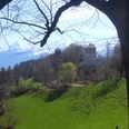
From Wimmis station, we follow the signs directly to the Niesen, which leads us to the Oberdorf district and the Bruchwald junction. Here, keeping right, the white-red-white marked hiking trail begins. Mostly through forest, it ascends noticeably, crossing an alpine road several times. After leaving the forest, we come to the small hut Vorder Ahorni, from where there is a brief, exceptional view of Lake Thun. After the hut, it soon goes back into the forest until Hindere Ahorni. A gently ascending traverse on the north side brings us over the Hundsrügg to the northwest ridge of the Niesen near Stueffistei. Here we sharply change direction and mostly climb near or on the ridge via Schafbode up to the west summit of the Niesen (P.2296). From here, the highest point of the Niesen is soon reached and we can enjoy the 360° panorama from the Swiss plateau to the High Alps before returning gently on the knees in the red car of the Niesen funicular back to the valley.

Good to know
Pavements
Best to visit
Equipment
We recommend the following equipment: sturdy hiking boots, medium-sized backpack with hip belt, sun protection, rainwear, hiking poles, first aid kit, picnic, enough fluids, mobile phone.
Directions & Parking facilities
Arrival: by train via Spiez to Wimmis
Return: by funicular from Niesen to Mühlenen, from there by train.
Additional information
Association Bernese Hiking Trails, Bern, Tel.: 031 340 01 01, e-mail: info@beww.ch, homepage: www.bernerwanderwege.ch
Literature
Hiking book Bernese Oberland of the Bernese Hiking Trails
License (master data)
Safety guidelines
This route runs wholly or partly on mountain hiking trails.
Map
swisstopo hiking map 253T Gantrisch
Nearby
")
")
")