


- 5:00 h
- 14.72 km
- 800 m
- 900 m
- 976 m
- 1,718 m
- 742 m
- Start: Habkern
- Destination: Kemmeriboden Bad
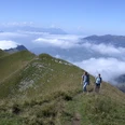
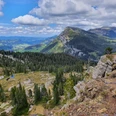
From the village center of Habkern into the valley to the Traubach bridge by Robert Maillart and uphill towards Bolsiten. The hiking trail follows the alpine road for a few hundred meters. Then it gently and steadily ascends on an old cattle drive way developed as a natural road, partly through forest but mostly over mountain pastures. A nice view down to Habkern with the Hardergrat in the background is already offered at Bolsitenallmi. The panorama at the Widegg is simply magnificent: On the broad grassy ridge a genuine pass experience unfolds. To the west and north, Gemmenalphorn and Hohgant are visible, to the east the elongated chain from Augstmatthorn to Brienzer Rothorn. In front stretches the wide Lombachalp, which also holds the source of the Emme – the river which gives the Emmental its name does not originate there, rather here in the Bernese Oberland.
The descent past the sun-browned huts of the Alpstafels Spycher and through beautiful stands of old pines and spruces to Schärpfeberg is delightful and pleasant. Here the route follows again a traditionally paved old alpine path. It then goes slightly steeper down to Hinter Hübeli, then practically level on an asphalt road to Kemmeriboden Bad.

Good to know
Pavements
Best to visit
Directions
Habkern - Widegg - Schärpfeberg - Kemmeriboden Bad
Equipment
We recommend the following equipment: light trekking shoes, light backpack, sun protection, rain jacket, pocket first aid kit, light picnic, sufficient fluids, mobile phone.
Directions & Parking facilities
Outbound journey: By train to Interlaken West. Then by bus to Habkern, Post
Return journey: By bus from Kemmeriboden Bad to Eschholzmatt.
Additional information
Association Bernese Hiking Trails, Bern, Tel.: 031 340 01 01, E-mail: info@beww.ch, Homepage: www.bernerwanderwege.ch
Literature
Hiking suggestion from the hiking book Thunersee - Frutigland, hiking book series of the Bernese hiking trails.
License (master data)
Safety guidelines
This route runs entirely on the hiking trail category.
Map
Swisstopo hiking map 1:50,000 254T Interlaken
Nearby


