


- 5:20 h
- 15.32 km
- 1,100 m
- 950 m
- 1,065 m
- 2,042 m
- 977 m
- Start: Lenk
- Destination: Lauenen
Lenk, formerly «Bedli», now a spa resort, is particularly proud of its healing springs. As early as 1689, the mayor and council of the city of Bern granted permission to "set up a sulfur spring as a bath." At that time, no one knew that the Balm spring is the most important and strongest sulfur spring in the Alps. The modern spa center built in 1977 optimally utilizes the health-promoting properties of this water. Legend connects the name Lenk with Longinus, a refugee from the Theban Legion. More likely, however, it derives from "a der lengen Egge," an outcrop of the Oberlaubhorn.
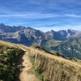
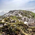
From the Lenk train station, take a short descent to the Simme bridge and into the village center. From the church, a gently ascending sidewalk leads to the entrance of the Wallbach Gorge. Stairs and steps pass through its most impressive part, offering insights into the striking erosion forms that water has carved over millennia. Now, on a well-maintained path with many steps up through the forested gorge slope to the Wallegg mountain hut. Along an almost invisible water conduit, the so-called water path leads through the wooded ravine slope to the footbridge over the mountain stream and steeply up on the opposite side to the pastures of In der Siten. First a forest road, then a path leads over flowery, partly marshy mountain meadows to Undere, then further to Obere Lochberg. The impressive moor landscape at Trütlisberg Pass is interspersed with marsh orchids, cotton grasses, and Arctic rush. Beautiful views from the pass peak into the Wildstrubel and Wildhorn area and down into the Lauenen valley. The gypsum fields of the Gryde near Stübleni appear snow-white. A more comprehensive panoramic view is available from the nearby Tube (2106 m; 15 min).
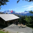
Continuing in the same direction, the route now descends diagonally over the pasture slope to the Vordere Trütlisberg hut, where the forest line is reached. Forest and pasture alternate pleasantly during the further descent to the hut group Uf der Flue. Shortly after crossing the Schwarzbächli and Mülibach in Rütschli, the path describes a large loop and finally follows the latter down into the village center of Lauenen, which is included in the Federal Inventory of protected heritage sites.

Good to know
Pavements
Best to visit
Directions
Equipment
Directions & Parking facilities
Outbound: by train via Zweisimmen to Lenk
Return: by post bus from Lauenen to Gstaad. From there by train to Zweisimmen
Additional information
Literature
Hiking suggestion from the hiking book Passwege in the Bernese Oberland, hiking book series of the Bernese hiking association
License (master data)
Safety guidelines
Map
Swisstopo hiking map 1:50,000 263T Wildstrubel
Nearby