


- 6:20 h
- 14.15 km
- 1,300 m
- 1,600 m
- 1,408 m
- 2,831 m
- 1,423 m
- Start: Kandersteg/Oeschinen
- Destination: Griesalp
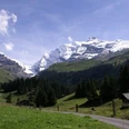
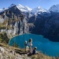
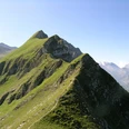
The ascent from the lake to Underbärgli through the rocky walls is full of wild beauty, and much steeper as you ascend between the rock bands to the alpine meadows of Oberbärgli. Over the elongated lateral moraine of the Blüemlisalp glacier, you climb into the scree slopes on the southern side of the Schwarzhorn. With every step, the view into the crevices and glaciers of the mountain giants becomes more comprehensive. Suddenly you stand at the pass height of the Hohtürli. The Blüemlisalphütte SAC is still about 60 m further up. Nearby rise the white peaks of the Blüemlisalp, in the main chain Morgenhorn, Wyssi Frau, and Blüemlisalphorn (highest peak of the massif, 3657 m). The mighty firn basin of the Blüemlisalp glacier is still impressive despite glacier retreat. The very steep descent on the Kiental side is on an excellently laid mountain path; however, caution is advised! Along an elongated rock ledge, the path winds down to the Obere Bundalp. A broad alpine path leads over Underi Bundalp, crossing the Bundbach twice, down to the Bundstäg, then turns uphill before this and reaches the Dündenessli meadow, hotel, and bus terminus Griesalp.

Good to know
Pavements
Best to visit
Directions
Oeschinen - Oeschinensee - Hohtürli - Bundalp - Griesalp
Equipment
We recommend the following equipment: sturdy mountain boots, medium-sized backpack with hip belt, sun protection, rainwear, hiking poles, first aid kit, picnic, enough fluids, mobile phone.
Directions & Parking facilities
Outbound journey: by train to Kandersteg. Then on foot to the valley station of the Oeschinenbahn. Take the gondola to the mountain station.
Return journey: by bus from Griesalp to Reichenbach station
Additional information
Bernese Hiking Trails Association, Bern, Tel.: 031 340 01 01, Email: info@beww.ch, Homepage: www.bernerwanderwege.ch
Literature
Hiking suggestion from the hiking book Thunersee - Frutigland, hiking book series of the Bernese Hiking Trails
License (master data)
Author´s Tip / Recommendation of the author
Start the route in Kandersteg and spend the night at the Blüemlisalphütte!
Safety guidelines
This route runs wholly or partially on mountain hiking trails.
Map
Swisstopo hiking map 1:50,000 263T Wildstrubel
Nearby