


- 4:30 h
- 16.99 km
- 270 m
- 230 m
- 524 m
- 567 m
- 43 m
- Start: Münsingen, Parkbad
- Destination: Thun, station
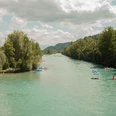
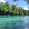
Past Bad Münsingen, the path crosses the Aare River via the Schützenfahrbrügg. The hike begins above the Aare on the slope of the Belpberg. Passing the Neumatt farmstead, it continues to the Ochsematt homestead, with splendid views of the Aare landscape and the Bernese Alps. The descent by Breitenried farm is easy; the following riverside section is wild. You will encounter floodplain forest, rapids, sandy bays, and reed beds. A soft footpath leads to the Thalgut. Behind the inn, the riverside path begins again, stretching to just before Jaberg. The Jaberg bridge takes you to the opposite bank of the Aare. The path to the mouth of the Rotache runs through a natural riverside landscape where you may spot sandpipers, common ringed plovers, and dippers. The Rotache footbridge is located slightly inland, and for the railway underpass, a short detour is necessary. Crossing the Aare again over the railway bridge near Uttigen, the hiking trail continues along the Upper Au, a forest area used by the military, on the Aare dam. Passing the monument for the Kander correction and over the Aarefeld footbridge, you arrive at Kaliforni. Soon the castle of Thun proudly marks the end of the hike. Passing the Schwäbis river bath, the old town of Thun and the gateway to the Bernese Oberland are reached.
For centuries, the Thalgut was the only inn on the Aare between Thun and Bern. A spa for rheumatism and gout was also very popular. The Thalgut bath was first mentioned in 1480. Its old name was “Zum Schiff”. The river formed a busy waterway from the Oberland; boatmen and rafters used to stop at the inn.
The Kander originally flowed through the Thuner Allmend and joined the Aare between Thun and Uttigen. In this flat area, it frequently caused floods. Therefore, at the beginning of the 18th century, the Kander was diverted into Lake Thun.
At the Aare near Uetendorf and Heimberg, the names Amerika-Egge and Kaliforni appear. However, no worries about being lost are necessary. One possible explanation for these unusual place names is that residents of these areas once emigrated to America.
The Schwäbis river bath is a small, charming facility. Since 1884, it has offered a cozy bathing atmosphere in a nostalgic setting and an exclusive swimming experience in the Aare over a length of 175 meters.
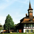
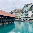
In the town of Thun, you can stroll through picturesque alleys, with numerous cafés along the Aare inviting you to linger. Thun is the gateway to the Bernese Oberland and is considered an ideal starting point for a variety of excursions and experiences.

Good to know
Pavements
Best to visit
Equipment
We recommend the following equipment:
Light trekking shoes, light backpack, sun protection, rain jacket, first aid kit, light picnic, sufficient fluids, mobile phone.
Luggage transport from stage accommodation to stage accommodation can also be booked at short notice via Eurotrek. Information and conditions at Eurotrek.ch
Directions & Parking facilities
By private car to Münsingen Badi/Parkbad.
Return trip from Thun station by train to Münsingen. On foot or by bus to Münsingen Badi.
Arrival: by train to Münsingen. Then by local bus to Münsingen Badi or Münsingen Allmendweg.
Departure: by train from Thun station.
Additional information
The ViaBerna is a multi-day hike that leads in 20 stages from Bellelay across the canton of Bern to the Susten Pass. Along the way, the hiker experiences the diversity of the canton of Bern in the Jura, the Central Plateau, and the Bernese Alps. The entire route is marked with route number 38.
Information about the ViaBerna multi-day hike can be found at viaberna.ch
License (master data)
Author´s Tip / Recommendation of the author
Accommodation tip Münsingen: Konzept Hotel Löie, Bernstrasse 28, 3110 Münsingen, Tel. 031 724 31 11, hallo.loeie@koncepthotels.com, www.koncepthotels.com/hotel-loeie-muensingen
Accommodation tip Thun: Hotel Aare Thun, Freienhofgasse 3, 3600 Thun, Tel. 033 227 50 50, info@hotelaarethun.ch, https://www.hotelaarethun.ch/
Hotel Holiday, Gwattstrasse 1, 3604 Thun, Tel. 033 334 67 67, info@holidaythun.ch, https://holiday-thun.ch/de/
Shopping options: Various shops in Münsingen and Thun. No opportunities along the way.
Safety guidelines
This route runs exclusively on marked paths of the hiking trail category.
Map
swisstopo hiking map 243T Bern and 253T Gantrisch 1:50,000
Nearby


