


- 6:15 h
- 17.04 km
- 1,200 m
- 940 m
- 847 m
- 1,880 m
- 1,033 m
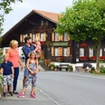
- Start: Aeschi bei Spiez, Post
- Destination: Saxeten
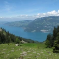
The start from Aeschi to Aeschiried already presents a panoramic view, close to the Niesen, the famous mountain pyramid on Lake Thun. After wonderful views of the Frutigland, a descending path soon branches off to the Suldbach and runs as a beautiful footpath along the river valley inward. In Suldweid you are in the middle of the Suldtal nature reserve. Through meadowland, you reach the mountain restaurant in Suld. The centuries-old storehouses, which stand under mighty maple trees, serve as cheese storage for the surrounding alpine pastures. Now the ascent begins through the wooded gorge of the Latrejebach. Soon a beautiful view opens up of the spraying Pochtenfall waterfall. Over pastures, you reach the huts of Schlieri. Small waterfalls also delight on the way to Mittelberg. The Latreje Alp beneath the rugged rock bands of the Schwalmere and the green slopes of the Dreispitz is one of the largest alpine pastures in the Oberland. From Mittelberg, the path winds in tight switchbacks to the Renggli Pass between Schwalmere and Morgenberghorn. Surprisingly, the view opens through the green Saxeten valley out to Lake Brienz. Caution is advised on the descent over the uppermost slope. Afterwards, a path leads to the huts of Mittelberg. The further descent through the valley flank and over mountain pastures to Innerfeld and into the village of Saxeten forms the end of the hike. Certain sections require caution; hiking in rain, snow, or fog is not recommended.
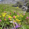
The Suldtal is considered a secret tip for animal and plant observations. The nature reserve is home to many black grouse, occasionally capercaillie, the rock ptarmigan, and even the rare alpine rock wren. A pair of golden eagles hunts the area; chamois and roe deer are also about, as well as fox, badger, marten, raccoon, and lynx. The richness of orchids is diverse. Gentian is also present; paradise lily, grass lily, or Turk's cap lily form entire fields, and the rare alpine columbine can also be found. Edelweiss, alpine sow-thistle, and alpine rose are also native.
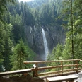
About 80 meters, the Latrejebach falls over a vertical rock face at the Pochtenfall into the valley. The natural spectacle is a popular excursion destination.
The path over the Renggli Pass was probably already used in pre-Roman times. Because an alpine festival once took place at the pass summit, the crossing is also called Tanzbödelipass.
The village of Saxeten lies 1,130 meters above sea level, nestled between Bällenhöchst, Sulegg, Schwalmere, and Morgenberghorn. Population-wise, Saxeten is one of the smallest municipalities in the Bernese Oberland.

Good to know
Pavements
Best to visit
Equipment
We recommend the following equipment:
Sturdy mountain boots, medium-sized backpack with hip belt, sun protection, rainwear, hiking poles, pocket pharmacy, picnic, sufficient fluids, mobile phone.
Luggage transport from one stage accommodation to the next can also be booked on short notice via Eurotrek. Information and conditions at Eurotrek.ch
Directions & Parking facilities
By private car to Spiez. Then by bus to Aeschi Post.
Return from Saxeten by bus to Wilderswil. From there by train via Interlaken Ost to Spiez.
Arrival: by train to Spiez. Then by bus to Aeschi, stop Post.
Return: by bus from Saxeten, Schulhaus to Wilderswil train station. From there by train to Interlaken Ost.
Additional information
The ViaBerna is a multi-day hike consisting of 20 stages, leading from Bellelay across the canton of Bern to the Susten Pass. Along the way, the hiker experiences the diversity of the canton of Bern in the Jura, the Plateau, and the Bernese Alps. The entire route is marked with route number 38.
Information about the multi-day hike ViaBerna can be found at viaberna.ch
License (master data)
Author´s Tip / Recommendation of the author
Shopping options: At the starting point in Aeschi. No shops along the way. On the return in Wilderswil
Accommodation tip Aeschi: Hotel Aeschi Park, Dorfstrasse, 3703 Aeschi bei Spiez, Tel. 033 655 91 91, info@aeschipark.ch, www.aeschipark.ch
Alternative: Restaurant Hotel Chemihütte, Ebenenfeld 4, 3703 Aeschi, Tel. 033 654 46 81, info@chemihuette.ch, www.chemihuette.ch
Accommodation tip Wilderswil: Gasthof Hirschen, alte Staatsstrasse 6, 3812 Wilderswil, +41 (0)33 822 35 51, hirschenwilderswil@hotmail.ch, www.hirschenwilderswil.ch
Alternative: Hotel Waldrand Unspunnen, Wagnerenstrasse 15, 3800 Interlaken, +41 (0)33 822 34 91, mail@waldhotel-interlaken.ch, www.waldhotel-interlaken.ch
Safety guidelines
This route runs fully or partly on marked paths of the mountain hiking trail category.
Map
swisstopo hiking map 253T Gantrisch and 254T Interlaken 1:50,000
Nearby


