


- 5:30 h
- 13.45 km
- 1,080 m
- 1,100 m
- 1,082 m
- 2,046 m
- 964 m
- Start: Saxeten, Schulhaus
- Destination: Isenfluh, village
Starting in the small mountain village of Saxeten, the hiking trail follows the rushing Saxetbach upstream towards Unterberg. About 300 meters after the power station, follow the mountain path ascending gently to the left to Alp Schlipfwengen. Here the trail turns right, first through a steep pasture and later through rock bands up to the Usserbällen alpine hut. A coffee at the stately table in front of the hut is well deserved. Flower-rich meadows line the ascent to Bällefurgge (point 1998). A detour to the nearby Bällehöchst viewpoint is recommended.
The crossing into the Jungfrau region then proceeds almost level through the scree slopes of the Tschingel. In poor weather conditions, caution is advised here. At the foot of the Schärihubel you enter the karst landscape of Suls. The Sulsseewli comes into view; the route keeps left to the Lobhorn hut, where there is a magnificent view of the Eiger, Mönch and Jungfrau triumvirate. Over Suls and above Chüebodmi the hike leads to Sulwald and from there to the mountain village of Isenfluh.
The Alp Suls and the Sulsseewli, lying in a hollow, are so beautiful that legend says they are inhabited by a landscape goddess and nature spirits. The fact is that depending on the weather, the mountain lake shimmers in various colors and has no above-ground outflow. Whoever takes their gaze away from the lake sees in the distance the five rocky peaks of the Lobhörner.
A short detour to Chüebodmi is worthwhile on the descent to Sulwald, where there is a huge boulder. According to legend, the indigenous people are said to have met here for the spring festival.
If you run out of breath in Sulwald, you are not lost. You can also take a small, almost nostalgic cable car to Isenfluh. According to the operators, the special "little train" offers space for eight people or one cow.
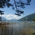
The small mountain village of Isenfluh lies at just under 1100 meters above sea level above the valley of the white Lütschine. Isenfluh offers a magnificent view of the famous Oberland triumvirate Eiger, Mönch and Jungfrau. The village belongs to the municipality of Lauterbrunnen. That Isenfluh has not become a tourist destination despite its scenic location is probably due to the long absence of road connections.

Good to know
Pavements
Best to visit
Directions
Saxeten – Schlipfwengen – Bällefurgge – Lobhornhütte – Sulwald – Isenfluh
Equipment
We recommend the following equipment:
Sturdy hiking boots, medium-sized backpack with hip belt, sun protection, rainwear, hiking poles, first aid kit, packed lunch, sufficient fluids, mobile phone.
Luggage transport from one stage accommodation to the next can also be booked at short notice via Eurotrek. Information and conditions at Eurotrek.ch
Directions & Parking facilities
By private car to Wilderswil. From there by bus to Saxeten.
Return from Isenfluh by bus to Lauterbrunnen and then by train to Wilderswil.
Arrival: by train to Interlaken Ost and then to Wilderswil. From there by bus to Saxeten Schulhaus.
Return: by bus from Isenfluh village to Lauterbrunnen. From there by train to Interlaken Ost.
Additional information
The ViaBerna is a multi-day hike which leads in 20 stages from Bellelay across the canton of Bern to the Susten Pass. Along the way, the hiker experiences the diversity of the canton of Bern in the Jura, in the midlands and in the Bernese Alps. The entire route is marked with route number 38.
Information about the multi-day ViaBerna hike can be found at viaberna.ch
License (master data)
Author´s Tip / Recommendation of the author
Shopping options: No shops along the way. At the start and end in Wilderswil or Lauterbrunnen.
Accommodation tip Wilderswil: GasthofHirschen, alte Staatsstrasse 6, 3812 Wilderswil, +41 (0)33 822 35 51, hirschenwilderswil@hotmail.ch, www.hirschenwilderswil.ch
Alternative: Hotel WaldrandUnspunnen, Wagnerenstrasse 15, 3800 Interlaken, +41 (0)33 822 34 91, mail@waldhotel-interlaken.ch, www.waldhotel-interlaken.ch
Accommodation tip Isenfluh: Hotel Restaurant Waldrand, Hofstettli 4185A, 3822 Isenfluh, Tel. 033 855 12 27, info@hotel-waldrand.ch, www.hotel-waldrand.ch
Alternative: Gasthof zur Linde, Dorfstrasse 75, 3815 Gündlischwand, Tel. 033 853 11 22, info@gasthofzurlinde.ch,www.gasthofzurlinde.ch
Safety guidelines
This route runs wholly or partly on marked trails of the mountain hiking path category. The Tschingel section between Bällefurgge and Schärihubel requires sure-footedness. In bad weather, additional caution is advised here. In early summer, there may still be residual snowfields. Therefore, we recommend hiking this stage only from July.
Map
swisstopo hiking map 254T Interlaken 1:50,000
Nearby
