


- 5:15 h
- 10.55 km
- 1,350 m
- 470 m
- 649 m
- 1,970 m
- 1,321 m
- Start: Isenfluh, village
- Destination: Schynige Platte
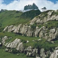
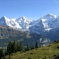
The hike begins in the mountain village of Isenfluh and leads over the old church path through forest and past streams and waterfalls down to the valley floor at Zweilütschinen. From the station building, you go downstream to the railway bridge over the Schwarze Lütschine. After the bridge, the path turns onto the old valley road into the Grindelwald valley and leads through the village of Gündlischwand. After leaving the village, the actual ascent to Iselten begins. In wide and tight switchbacks, the path winds uphill through shady forest. In an area with loose rock formations, it squeezes through a rock gate formed by two steep limestone rocks. The locals call this passage "Angel's Gate," because if you're very good, you are supposed to hear the angels sing here. In Ussren Blatti, the open alpine pastures begin, with a wonderful view deep into the Grindelwald valley. From the huts of Ausserläger, you overlook the whole pasture basin of Alp Iselten and climb through the sunny slope to Oberberg. From here, the trail coming from Faulhorn leads to Schynige Platte. The view of the Jungfrau group is overwhelming.
Especially during high water, the confluence of the Schwarze Lütschine and Weisse Lütschine at Zweilütschinen presents an impressive sight: From the east, the darkly colored waters of the Schwarze Lütschine, stained by slate mud, surge in and mix with the water of the Weisse Lütschine, which originates in the limestone-rich Lauterbrunnen valley.
The Schynige Platte is accessible by a cogwheel railway from the "Belle Epoque" and is a popular starting point for many hikes. Wooden benches in the train cars, rolling stock from the 19th century, and the historical uniforms of the train attendants recall times gone by.
Climbing onto a rock ledge at life-threatening risk to discover rare mountain flowers? This is not necessary in the botanical alpine garden on Schynige Platte. To see the edelweiss up close, no one needs to put themselves in danger. In the alpine garden, it grows together with black gentian, the paradise lily, and around 650 other species in an easily accessible environment. On a roughly one-kilometer-long circular route, visitors can observe two-thirds of the entire alpine flora and walk through artificially created terrains such as the primary rock field or the lime scree slope, where very specific species thrive. Ice axes, ropes, and carabiners can stay at home.

Good to know
Pavements
Best to visit
Directions
Isenfluh – Zweilütschienen – Gündlischwand – Isleten – Schynige Platte
Equipment
We recommend the following equipment:
Sturdy mountain boots, medium-sized backpack with hip belt, sun protection, rainwear, trekking poles, small first aid kit, picnic, sufficient drinks, mobile phone.
Luggage transport from stage accommodation to stage accommodation can also be booked at short notice via Eurotrek. Information and conditions at Eurotrek.ch
Directions & Parking facilities
By private car to Wilderswil. From there by train to Lauterbrunnen and by bus to Isenfluh village.
Return trip from Schynige Platte by train to Wilderswil.
Arrival: by train to Interlaken Ost. Then by train to Lauterbrunnen. From there by bus to Isenfluh stop Dorf.
Return: by Schynige Platte railway to Wilderswil and then by train to Interlaken Ost.
Additional information
The ViaBerna is a multi-day hike which in 20 stages leads from Bellelay across the canton of Bern to the Susten Pass. The hiker experiences the diversity of the canton of Bern in the Jura, the Central Plateau, and the Bernese Alps. The entire route is marked with route number 38.
Information about the multi-day hike ViaBerna can be found at viaberna.ch
License (master data)
Author´s Tip / Recommendation of the author
Shopping options: No shops along the way. In the surrounding villages of Wilderswil and Lauterbrunnen, there are Volg branches.
Accommodation tip Isenfluh: Hotel Restaurant Waldrand, Hofstettli 4185A, 3822 Isenfluh, Tel. 033 855 12 27, info@hotel-waldrand.ch, www.hotel-waldrand.ch
Alternative: Gasthof zur Linde, Dorfstrasse 75, 3815 Gündlischwand, Tel. 033 853 11 22, info@gasthofzurlinde.ch, www.gasthofzurlinde.ch
Accommodation tip Schynige Platte: Berghotel Schynige Platte, 3822 Wilderswil, Tel. 033 828 73 73, hotel.schynigeplatte@jungfrau.ch, www.hotelschynigeplatte.ch
Alternative: no direct alternative on Schynige Platte. Depending on the stage division, the Berghaus Männdlenen, the Faulhorn, and later the Grosse Scheidegg can be alternatives.
Safety guidelines
This route runs completely or partly on signposted trails of the mountain hiking path category.
The ascent from Zweilütschienen to Schynige Platte is strenuous. As an alternative, you can take the Schynige Platte railway from Wilderswil. Instead of the ascent, the large circular route on Schynige Platte can be done.
Map
swisstopo hiking map 254T Interlaken 1:50,000
Nearby

