


- 4:15 h
- 9.97 km
- 1,200 m
- 130 m
- 1,169 m
- 2,222 m
- 1,053 m
- Start: Gadmen, bus stop Post
- Destination: Susten Pass, summit
After starting in the beautiful mountain village of Gadmen, the route leads via Obermad to the old pass route. The Reissend Nollen, Titlis, Grassen and Fünffingerstöck towers impressively over the Wendental. Passing the huts on the Alp Wyssenmad, it goes to the panoramic height of Steinweng. Along the way, a look back into the Gadmen valley is worthwhile. The area is of wild beauty. A slab path leads through the marshy raised bog landscape to the alpine centre in Steingletscher. The ascent to the Susten Pass lets you immerse ever deeper in the mountain world. At the Susten Pass summit at 2259 meters above sea level is the border to the Canton of Uri. Here is also the moment to bid farewell to the ViaBerna.
The old Susten path, embedded in a wild mountain landscape, is considered one of the most beautiful pass routes in Switzerland with its high natural retaining walls and stone slabs. Since its restoration in 1993, you can follow the old pass path away from the traffic. In the unique mountain landscape with roaring mountain waters, you gain insight into the technique of the path builders of the time.
This is how the pass road was built: When Valais was annexed by France in Napoleon's time, Bern sought a replacement for the Grimsel route to avoid high customs duties. In 1811, the cantons of Bern and Uri built the road connection over the Susten Pass, which lost importance quickly after Napoleon's fall and especially after the construction of the new pass road. In 1993, the former connection was restored as a witness of old pass road construction art.
The current pass road is 45 km long and was built between 1938 and 1945. Because it mainly serves tourism, it is usually only open from June to October.
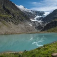
On the ascent to the Susten Pass, the alpine mountain world can be impressively experienced. From the firn summits of the Susten and Gwächtenhorn, the Tierberg and the Giglistock, ice flows drop down to the Steinalp.
The ViaBerna is a continuously signposted attractive hiking trail that leads from Bellelay in the Bernese Jura across the canton of Bern to the Susten Pass. The route realized by Bernese hiking trails has a length of around 300 kilometers and covers 20 stages.

Good to know
Pavements
Best to visit
Directions
Gadmen – Wyssemad – Steingletscher – Susten Pass
Equipment
We recommend the following equipment:
Sturdy mountain boots, medium-sized backpack with hip belt, sun protection, rainwear, hiking poles, pocket first aid kit, picnic, sufficient fluids, mobile phone.
Luggage transport from one stage accommodation to the next can also be booked at short notice via Eurotrek. Information and conditions at Eurotrek.ch
Directions & Parking facilities
Outbound journey: by train to Innertkirchen Grimseltor. Then by bus to Gadmen Post.
Return journey: by bus from Susten Pass summit to Innertkirchen Grimseltor.
Additional information
The ViaBerna is a multi-day hike which in 20 stages leads from Bellelay across the canton of Bern to the Susten Pass. Along the way, the hiker experiences the diversity of the canton of Bern in the Jura, the Central Plateau, and the Bernese Alps. The entire route is signposted with route number 38.
Information about the multi-day hike ViaBerna can be found at viaberna.ch
License (master data)
Author´s Tip / Recommendation of the author
Shopping options: Alpine cheese dairy Steingletscher on the eponymous alp with regional alpine products.
Accommodation tip Gadmen: Hotel Restaurant Gadmer Lodge, Gadmen 283a, 3863 Gadmen, Tel. 033 975 00 30, info@gadmerlodge.ch, www.gadmerlodge.ch
Accommodation tip Susten Pass: Mountain Hotel Steingletscher, 3863 Steingletscher, Tel. 033 975 12 22, info@sustenpass.ch, www.sustenpass.ch
Alternative: Mountain inn Susten Hospiz, 6484 Wasen, Tel. 033 975 14 05, info@sustenpass‐hospiz.ch,
Safety guidelines
This route runs wholly or partly on signposted paths of the mountain hiking trail category.
Map
swisstopo hiking map 255T Susten Pass 1:50,000
Nearby