


- 2:10 h
- 8.06 km
- 83 m
- 96 m
- 559 m
- 654 m
- 95 m
- Start: Allmendingen, village
- Destination: Gwatt, Deltapark
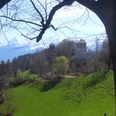
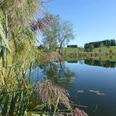
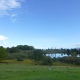
From the end bus stop Allmendingen first take a few steps through Wylergasse, then turn right and follow the renatured Allmendingen stream. Above the forest, the mighty splendor of the Stockhorn range can be seen. On a well-maintained gravel path, it goes to Wasserflue in the Glütschbach valley forest. Before the Kander was led into the Thunersee lake at Einigen, it flowed here. Since then, instead of a rushing mountain stream, an idyllic forest brook flows through the plain. At the signpost site Tropfsteinhöhle, bizarre rock formations attract child explorers; directly on the water there is also a generously equipped picnic area. Sometimes along the stream, then a bit away from it, the path continues on gravel and finally on a short asphalt section to Guntelsey. At the restaurant, turn right into the forest. The hike on the idyllic forest path is initially somewhat disturbed by the noise of the nearby parallel highway. At the Alte Schlyffi, turn left onto the hiking route towards Gwatt, go under the highway, and then reach Gwattegg with a short climb. The ridge path over the Strättlighügel ridge to Strättligturm offers a wonderful view of Lake Thun and the Alpine peaks. The tower was built around 1700 by the canton of Bern as a powder magazine on the ruins of a castle destroyed in 1332 belonging to the Freiherren von Strättligen. Through the wild gorge of the Kander (which formed in the 18th century after an attempt was made to direct the river through a tunnel into Lake Thun at this point), it goes to Chanderbrügg near Einigen. Through the floodplain landscape of Chandergrien, you reach Delta-Park and finally the bus stop of the same name.

Good to know
Pavements
Best to visit
Directions
Allmendingen - Guntelsey - Gwattegg - Strättligenturm - Chandergrien - Gwatt
Equipment
We recommend the following equipment: lightweight trekking shoes, light backpack, sun protection, rain jacket, pocket first aid kit, light picnic, sufficient fluids, mobile phone.
Directions & Parking facilities
Outbound: Take STI bus no. 3 from Thun train station to Allmendingen, village
Return: Take STI bus no. 1 from Gwatt, Deltapark to Thun train station
Additional information
Berner Wanderwege, T 031 340 01 01, info@beww.ch, bernerwanderwege.ch
Literature
Hiking suggestion from the hiking book Short Walks, hiking book series of Berner Wanderwege
License (master data)
Author´s Tip / Recommendation of the author
Safety guidelines
This route runs entirely on hiking trails.
Map
Swisstopo hiking map 1:50,000 253T Gantrisch
Nearby

