- 5:35 h
- 14.21 km
- 950 m
- 950 m
- 1,761 m
- 2,328 m
- 567 m
- Start: Brienzer Rothorn
- Destination: Brienzer Rothorn
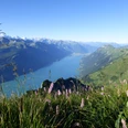
From the Rothorn station to the hotel and past the mountain station of the Sörenberg–Brienzer Rothorn cable car to the summit of the Brienzer Rothorn. The view from the 2,349 m high mountain is magnificent: To the north, on clear days, you can see over the Swiss Midlands and Jura to the Black Forest, the Vosges, and the Rhine valley between the two mountain ranges. Peak after peak follows from Säntis in the northeast over the Glarus and Central Swiss Alps to the Bernese Alps and the Diablerets in the southwest. An unbroken mountain ring of overwhelming power and beauty!
From the summit, you reach the Eisee saddle in a rapid descent with a few switchbacks. The well-maintained high trail then ascends evenly to another viewpoint, Arnihaaggen. The descent on its east flank is again done in zigzags. The path then only slightly descends into the south flank of the Höch Gumme (high trail to Schönbühl 15 min) and leads along the ridge of the Scheidegg southwards towards the Wilerhorn. At the saddle before the Hörnli, a path branches off from the ridge top into the lake side flank of the Wilerhorn. On this path, you reach the turning point of the circular hike (to Wilervorsess–Brünig pass height 2h). The impressive deep view overlooks the Brienzersee, the Bödeli, and even a piece of the Thun lake. First a level path, then gently up and down to the huts at Chäseren. Slightly ascending, it crosses the wild catchment area of the Lammbach. Numerous walls protect against rockfall, landslides, and avalanches. Through the upper part of the heavily reforested Alp Gibelegg, you reach the ridge top again at the Eisee saddle and ascend in just under an hour to the Brienzer Rothorn.

Good to know
Pavements
Best to visit
Directions
Equipment
Directions & Parking facilities
Additional information
Literature
Hiking suggestion from the Bernese Oberland hiking book, hiking book series by the BWW
License (master data)
Safety guidelines
This route runs entirely or partly on marked paths of the mountain hiking trail category
Map
Swisstopo hiking map 1:50,000 254T Interlaken
Nearby