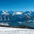
The Niederhorn towers over Lake Thun at an elevation of 1,950 metres above sea level. From the summit, you can savour a panorama of Alpine peaks encompassing the Eiger, Mönch and Jungfrau. It is a 10-minute walk from the Niederhorn summit station to this unique Grand Tour of Switzerland photo spot, which also marks the start of a breathtaking ridge trail.
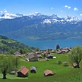
The peerless location of the Niederhorn promises a stunning panoramic view towards the Central Plateau, with the towns of Thun and Bern visible across the Bernese Alps.
The peerless location of the Niederhorn promises a stunning panoramic view towards the Central Plateau, with the towns of Thun and Bern visible across the Bernese Alps.
Your highlights at a glance
- The Grand Tour of Switzerland is a 1,600 km tourist circuit spanning the country
- Discover scores of attractions along the way
- Take a souvenir snap at the Niederhorn photo spot
- Enjoy the spectacle of the ice-crested giants of the Eiger, Mönch and Jungfrau.
To ensure that your trip is perfect in every way
- Download the Grand Tour of Switzerland app (iOS/Android)
- The whole of the route is generally open to cars and motorcycles
- Parking is available at the Beatenbucht and Beatenberg stations
- The walk from the summit station to the photo spot takes around 5 minutes
- Note the seasonal opening times of the Niederhorn Cable Car
Good to know
Openings
Observe the operating times of the mountain railways
License (master data)

Our recommendations

Nearby