


- 3:00 h
- 10.10 km
- 137 m
- 660 m
- 565 m
- 1,098 m
- 533 m
- Start: Brünig Pass
- Destination: Brienz
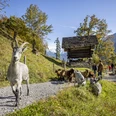
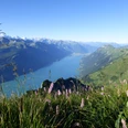
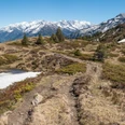
From Brünig Pass station, follow the pass road past the Kulm restaurant until a sign points right towards Brienzwiler / Brienz (approx. 15 minutes). To the Brääch alpine hut, the route goes on an alpine road and then on a hiking trail, gently ascending into the Uochwald forest. The signposted detour to the Tschuggen viewpoint should not be missed, as the short detour (approx. 15 minutes round trip) is worthwhile, offering a wonderful view of Lake Brienz and the entire Hasli valley. Back at the junction, the path descends through the forest until after the bridge you turn left and continue down to Brienzwiler. Through the village, follow signs towards Brienz. After Bifing, keep right to stay on the right side of the small plain crossed by the Fulbach stream. On the other (southern) side is the area and the west entrance of the Ballenberg open-air museum.
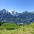
At the first intersection in Hofstetten, turn left following signs to Brienz through the small village. Shortly after leaving Brienz, a path branches off to the right, leading along meadows with a beautiful view of Lake Brienz and soon reaches Schwanden near Brienz. The path leads directly down to the lakeshore at the entrance to Brienz. Along the wonderful lakeside promenade, it takes about 10 minutes to reach Brienz station.

Good to know
Pavements
Best to visit
Directions
Equipment
Directions & Parking facilities
Arrival: by train via Brienz or Lungern to Brünig-Hasliberg
Return: by train from Brienz station
Additional information
Literature
Hiking guide Bernese Oberland by the Bernese Hiking Association
License (master data)
Safety guidelines
Map
Swisstopo hiking map 254T Interlaken 1:50,000
Nearby


")
")