


- 4:30 h
- 11.01 km
- 1,000 m
- 650 m
- 1,180 m
- 1,913 m
- 733 m
- Start: Gsteig
- Destination: Col du Pillon
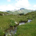
From the village center of Gsteig, follow the main road downstream to the Hotel Viktoria. Now on a farm road to the small stream in the forest. Before the bridge, a path branches off uphill and leads steeply over clearings and through mountain forest up to the Schopfi pasture. Zigzagging, continue steeply upwards – sometimes on a faint path, sometimes pathless – to the middle hut of the Alp Vordere Walig. Continuing to ascend, now again on a forest road, you enjoy a splendid view to the north over the Saane valley to the Hundsrügg.
Above the ridge of the Wispile, Wasserngrat, Giferspitz, and Lauenehore are visible. On the nearby mountains of the Sanetsch region, it is evident how much the different rock layers were mixed during the formation of the Alps. The forest road continues on flat terrain to the Alp Topfelsberg. However, 100 more meters of elevation must be overcome to the Blattipass, a gentle crossing in the Seeberghorn range (to Arnensee 35 min; to Unter Stuedeli–Linders Vorschess–Feutersoey 2h10).
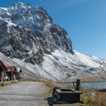
Beautiful view of the snow-covered mountains of the Bernese Alps from the distinctive peak of the Eiger in the east to the Geltenhorn above the ridge connecting Spitzhorn and Arpelistock. From the pass, following varying slopes on path traces – sometimes pathless – past the Ober Stuedeli alpine hut to the two huts of the Alp Seeberg (to Arnensee 50 min; to Hinter Walig–Feutersoey 2h15). Between the buildings, steeply uphill toward Seeberghorn. Magnificent view back over the Tschärzistal with the forest-surrounded Arnensee. Shortly after the small lake, at point 1919 near Chalet Vieux, you cross the cantonal border and at the same time change from the Tschärzistal to the Pillon area. Magnificent view into the Diablerets and Olden area. The path winds steeply downhill and follows the slope through loose woodland to Lac Retaud, a gem in the Vaud Prealps. Avoiding the farm road, it goes down through light spruce and mountain pine forest, past unusual hills and gypsum funnels to the pass height of Col du Pillon.

Good to know
Pavements
Best to visit
Directions
Equipment
Additional information
Literature
License (master data)
Safety guidelines
Map
Nearby
