


- 6:50 h
- 14.84 km
- 1,700 m
- 1,200 m
- 1,105 m
- 2,653 m
- 1,548 m
- Start: Lenk / Simmefäll
- Destination: Lenk / Iffigenalp
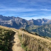
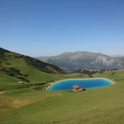
The day begins with an ascent along the misting Simmenfälle to the Barbara bridge. Over several cascades, masses of water tumble over rocks and shroud the surroundings in water mist. The Barbara bridge or the dam in front of the waterfall is a weir for diverting the young Simme. This measure to protect the valley floor from flooding was already taken in the late 18th century. Barbara was the first name of the wife of the then director of the spa, who initiated and financed the development of the Simmenfälle and the weir for tourists. The path winds up through the forest. Deep cuts carved by the Simme into the rock can be seen. Arriving at Alp Rezliberg, we are at the birthplace of the Simme. At the foot of the mighty limestone wall, the Simme bursts forth foaming white. In summer, up to 2800 liters per second flow over the seven springs, called Siebenbrünnen. Accompanied by flowing water, the path climbs steeply to Fluesee. This lies on a high plateau and is nestled on one lake side by the massif of Ammertehore. Sheep are grazed here, some of which curiously sniff at the hikers. The view over the village of Lenk and far down the valley is wonderful from Fluesee. While still green at Fluesee, the landscape above Tierberg is rather barren and rocky. Over the Glacier stream bridge it goes towards Tierbergsattel. Tierbergsattel is the highest point of the route. Not to be missed from here is the view of the surrounding mountain lakes and peaks, foremost the side profile of the Gletscherhorn which surprisingly looks like a polished stone from this angle. From here it goes downhill to Rawilseeleni. The Rawilseeleni, cooled by meltwater, invite you to a refreshing swim. Over the former mule track, a connection between Wallis and the Simmental, it goes steeply downhill over the exposed path down the falling rock face from Stiereläeger. Shortly before Iffigenalp the tree line is reached and the path runs bordered by trees to the stage destination.

Good to know
Pavements
Best to visit
Directions
Simmefäll - Sibe Brünne - Fluesee - Tierbergsattel - Rawilseeleni - Iffigenalp
Equipment
We recommend the following equipment: sturdy mountain boots, medium-sized backpack with hip belt, sun protection, rainwear, hiking poles, pocket pharmacy, picnic, sufficient fluids, mobile phone.
Directions & Parking facilities
Outbound journey: By train to Lenk and then by bus to the Simmenfälle.
Return journey: From Iffigenalp by bus to Lenk.
Additional information
Association Berner Hiking Trails, Bern, Tel.: 031 340 01 01, e-mail: info@beww.ch, homepage: www.bernerwanderwege.ch
License (master data)
Author´s Tip / Recommendation of the author
Check accessibility at the Tourist Center in advance! Possibly consider a 2-day route with an overnight stay at the Wildstrubel hut SAC!
Safety guidelines
Challenging, sure-footedness and no fear of heights required: Glacier stream crossing no later than noon! Afterwards, the passage might no longer be possible. This route runs entirely or partly on marked paths of the mountain hiking trail category.
Map
Swisstopo hiking map 263T Wildstrubel 1:50,000
Nearby
