
- 1:45 h
- 5.47 km
- 20 m
- 820 m
- 1,156 m
- 1,951 m
- 795 m
- Start: Beatenberg, Niederhorn
- Destination: Beatenberg, Wydi bus stop
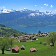
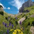
The Niederhorn, truly a box seat with Eiger, Mönch and Jungfrau as a backdrop. The detour to the summit is a must as it offers breathtaking views of the Eiger, Mönch and Jungfrau trio, over Lake Thun, Thun and the Aare valley up to the Jura mountains. Furthermore, and only here, the impressive view into the Justistal valley with the rounded valley end of the Sichle, the pass crossing into the Eriz. At the start, follow the sign Oberburgfeld. A pleasant path leads without major altitude differences towards Burgfeldstand. There is an ibex colony here. With a bit of luck, the animals can be observed up close as they have lost all fear of humans. It is worth pausing now and then to enjoy the view of the Eiger, Mönch and Jungfrau. At Hohseil, head towards Oberburgfeld. Now the path leads through meadows, open woods and finally along the forest edge down to Unterburgfeld, continuing on a path through forest and a moor area down to Bireflue. From here, the route goes down steeply in a zig-zag path to Beatenberg/Spirewald. A signpost with the location Spirewald 1320m confirms that you are on the right path. From here the tour is marked as a hiking trail down to Beatenberg/Wydi to the destination, the Beatenberg Wydi bus stop.

Good to know
Pavements
Best to visit
Directions
Equipment
Directions & Parking facilities
Outbound journey: By train to Thun, continue by bus to Beatenbucht, and then by funicular and cable car to Niederhorn
Return journey: By bus from Beatenberg Wydi to Interlaken West
Additional information
Literature
Hiking book short hikes 2 of the Bernese Hiking Trails, order at: https://www.wanderplaner.ch/sommer/web-shop/
License (master data)
Safety guidelines
Map
Swisstopo hiking map 254T Interlaken 1:50,000, order at: https://www.wanderplaner.ch/sommer/web-shop/
Nearby


")
")
")