


- 3:20 h
- 7.97 km
- 570 m
- 615 m
- 562 m
- 1,177 m
- 615 m
- Start: Sundlauenen
- Destination: Merligen, Beatenbucht
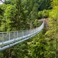
From the STI stop "Sundlauenen village" it goes up over asphalt road to the lakeside road. There, the hiking route leads through the forest to Ruchenbühl—a first steep ascent is accomplished. A meadow path finally leads to the single-rope suspension bridge. High above the Sundgraben, standing on metal grates, you can catch a view of Lake Thun. The suspension bridge leads the hikers in a gentle left curve and by means of stairs back onto solid ground up into the shady Schwendi forest area. Before going upwards again, the route crosses a larger stream on a wooden bridge. The path to Beatenberg is anyway lined with many small water streams that have created an enchanting landscape. It is worth stepping away here and there from the actual hiking trail to enjoy views through the bright branches of the Lake Thun region or the mirrored worlds of the small water spots. Most of this long forest section towards Beatenberg is characterized by stair landings. The last section up to Beatenberg Church leads over meadows.
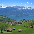
Arriving in Beatenberg, numerous inns on the way to the Niederhorn cable car station invite you to take an extended break—after all, not only food and drink beckon, but generally also an incomparably beautiful view of Lake Thun and the mountains. Behind the cable car station building, the hike continues first over stairs to Beatenbucht. The route—initially still over asphalt roads—becomes a bit steeper on the meadow and forest paths. However, the stretch is very manageable. Beautiful views and fascinating flora and fauna invite frequent pauses. Twice the path crosses the route of the cable car that connects Beatenberg with the bay. From Schocken it goes over Birchi and Sack, finally to Fischbalmen. From there, the last meters to Beatenbucht are really relaxing. At the destination—the STI stop "Beatenbucht"—there is again the opportunity to enjoy waiting for the bus with a rest in the restaurant directly on the lake.

Good to know
Pavements
Best to visit
Directions
Equipment
Directions & Parking facilities
Outbound journey: STI Bus No. 21 from Thun or Interlaken to Sundlauenen village
Return journey: STI Bus No. 21 from Beatenbucht to Thun or Interlaken
Additional information
License (master data)
Author´s Tip / Recommendation of the author
Further similar offers in the region can be found at: https://www.stibus.ch/ausflugsziele
Safety guidelines
Map
Swisstopo hiking map 254T Interlaken 1:50,000 available in the shop of Berner Wanderwege
Nearby


")
")