- 3:10 h
- 6.22 km
- 680 m
- 680 m
- 1,079 m
- 1,650 m
- 571 m
- Start: Suld, Restaurant
- Destination: Suld, Restaurant
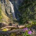
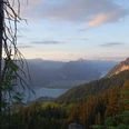
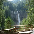
From the Pochtenfall restaurant, follow the signage on the left side of the Pochtenfall and the Suld to the Louene junction (P.1361). Here, turn left and now climb steeply over alpine meadows towards Brunni. When reaching the Huetmad alpine hut (1582 m), the path noticeably flattens, and the strenuous part of the hike is done. It continues mostly at a constant altitude to the Brunnihütte (1646 m), where some slightly exposed sections require attention to smaller children. A rest can be taken either at the Brunnihütte or, better yet, on the grassy knoll P.1660 of the Brunnigrind, 200 m away, where a bench is located and from where you have a wonderful view over Lake Thun. Overnight stays are possible at the Brunnihütte on weekends; a cooking facility and kitchen utensils for self-catered meals are available. Drinks, cake, alpine cheese, and sausage are available at any time.
From the Brunnihütte, follow the path towards Aeschiried. Shortly after P.1551, leave this path to the right, arriving at the hut near Greberegg (P.1522). Keeping left, descend again to Suld through a beautiful forest path. The Pochtenfall restaurant with its lovely beer garden invites you for a final drink. For the children, a trampoline is available in the playground. A swim in the Suld is also not to be missed.

Good to know
Pavements
Best to visit
Directions
Equipment
We recommend the following equipment: sturdy mountain boots, medium-sized backpack with hip belt, sun protection, rain gear, hiking poles, first aid kit, picnic, sufficient fluids, mobile phone.
Directions & Parking facilities
Arrival: by bus from Spiez train station via Aeschiried to Gasthaus Suld
Return: by bus from Gasthaus Suld via Aeschiried to Spiez train station
Additional information
Bern Hiking Association, Bern, Tel.: 031 340 01 01, Email: info@beww.ch, Website: www.bernerwanderwege.ch
License (master data)
Safety guidelines
This route runs entirely or partly on marked trails of the mountain hiking path category.
Map
swisstopo hiking map 254T Interlaken 1:50 000
Nearby