


- 7:00 h
- 10.67 km
- 1,170 m
- 1,170 m
- 1,079 m
- 2,249 m
- 1,170 m
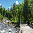
- Start: Gasthaus Suld, Suldtal
- Destination: Gasthaus Suld, Suldtal
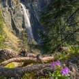
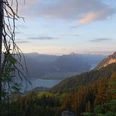
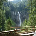
Experienced mountain hikers will enjoy this hike. The route starts right away with a highlight: the Pochtenfall. From here, it goes steeply up to the Rengglipass. On the Renggli Alp, magnificent flower meadows allow for a break. Here you have to gather energy; the ascent to the Morgenberghorn is even more strenuous. Once at the top, the breathtaking panorama makes up for the exertion: the view includes the impressive Bernese 4,000-meter peaks and stretches beyond the flat Mittelland to the Jura. Far below in the valley glistens the deep blue Lake Thun.
Turning away from this view is not easy, but the descent demands utmost concentration again. The path to Brunni is steep and includes two chain-secured passages. Via Brunni, it goes through the rear Leimerwald back to the Restaurant Gasthaus Suld.
Looking for more hikes?
Find more inspiration about hiking options in the Bernese Oberland here.

Good to know
Pavements
Best to visit
Directions
Starting point Restaurant Gasthaus Suld, Suldtal, then continue over the Rengglipass to the Morgenberhorn, from here the descent begins via the Brunni back to the Restaurant Gasthaus Suld, Suldtal.
Equipment
- Wear sturdy hiking boots with a grippy sole
- Use trekking poles for demanding mountain hikes
- Dress according to the weather
- Don't forget rain protection
- Take a backpack with a picnic and water
- Protect yourself with sunglasses, a hat, and sunscreen
- A small first aid kit for injuries and blisters is recommended
- Take your smartphone for emergencies
- Pack as little as possible, as much as necessary
Directions & Parking facilities
Additional information
Aeschi Tourism
Scheidgasse 8
3703 Aeschi
Tel.: +41 33 654 14 24
info@aeschi-tourismus.ch
www.aeschi-tourismus.ch
Interlaken Tourism
Marktgasse 1
3800 Interlaken
Tel.: +41 33 826 53 00
info@interlakentourism.ch
www.interlaken.ch/wandern
License (master data)
Author´s Tip / Recommendation of the author
Safety guidelines
Fear of heights and sure-footedness are required on this route. Safety chains are installed at the most exposed points to hold on to. Good fitness is required for the panoramic hike.
The route corresponds to difficulty level T3 – challenging mountain hiking according to the SAC scale
Nearby
