


- 6:00 h
- 16.14 km
- 950 m
- 720 m
- 1,910 m
- 2,666 m
- 756 m
- Start: Schynige Platte
- Destination: Grindelwald/First
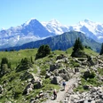
At the terminus of the cog railway on the Schynige Platte, you stand directly in front of the entrance to the alpine garden. The trailhead signpost for the hike is a little further back. This is also where the nearly two-hour panoramic circular trail branches off, leaving no wishes unfulfilled regarding views and perspectives. Even here, the Eiger, Mönch, and Jungfrau show themselves in incomparable majesty, and the views down into the two Lütschine valleys are also impressive.
Initially, the trail passes by the alpine huts of Oberberg almost on flat terrain through flower-rich alpine meadows at the west slope of the Loucherhorn. At the Louchera Grätli, the panoramic circular trail joins the main route. The Loucherhorn is bypassed southward. Once again, there is a magnificent view of the high alpine peaks. Through a natural gate in a rock ridge, the Güwtürli, you turn into the rocky landscape of the Güw. The small spruces struggling for survival form the only touches of color in the inhospitable karst landscape. On the Egg you switch to the flank of the rock towers of the Sägissa high up in the Sägistal. Striking here is the monotony of the vegetation. The short-mown grass is typical for intensive grazing by sheep. Numerous are the scree plants such as round-leaved pennycress, alpine cress, and large-flowered gentian.
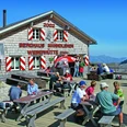
The ascent to the Männdlenen saddle between Sägissa and Winteregg leads through a rocky valley floor that melts out only in high summer. Now on a wide path through a rock wall and over flat terrain to the Fulegg (via Bättenalp to Iseltwald 4h10, caution!). Crossing the south slope, you then ascend to the Faulhorn. Sunrise and sunset from this viewpoint are equally fascinating. The hospitality of the 175-year-old mountain hotel is also gratefully enjoyed.
The descent via the Gassenboden to Bachalpsee is quite steep but takes place on a well-constructed wide path. The view over the dark water surface to the Wetterhorn group, Schreckhorn, and Finsteraarhorn is incomparable and expands significantly at the First, where the two Grindelwald glaciers and the Eiger also come into view.

Good to know
Pavements
Best to visit
Directions
Schynige Platte - Louchera Grätli - Faulhorn - Bachalpsee - Grindelwald/First
Equipment
We recommend the following equipment: sturdy mountain boots, medium-sized backpack with hip belt, sun protection, rainwear, trekking poles, first aid kit, picnic, sufficient liquids, mobile phone.
Additional information
Bernese Hiking Trails Association, Bern, Tel.: 031 340 01 01, E-Mail: info@beww.ch, Homepage: www.bernerwanderwege.ch
Literature
Hiking suggestion from the Jungfrau Region Brienz Lake - Oberhasli hiking guidebook series of the Bernese hiking trails
License (master data)
Safety guidelines
This route runs entirely or partly on marked paths of the mountain hiking trail category.
Map
Swisstopo hiking map 1:50,000 254T Interlaken
Nearby
