
- 6:40 h
- 16.58 km
- 1,430 m
- 1,200 m
- 1,408 m
- 2,613 m
- 1,205 m
- Start: Griesalp
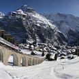
- Destination: Mürren
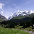
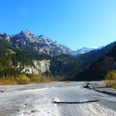
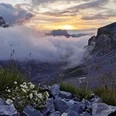
From Hotel Griesalp valley inward and initially gently ascending, mostly through forest over Dündenessli down to the Gamchibach. Over the Bundstäg you change to the other side of the valley and turn in at the Sennhütte Bürgli into the flank of the Dürreberg. From the hut Uf de Hüble you can enjoy a wonderful view of the rocky peaks of Zahm and Wild Andrist as well as the glaciers on the Blüemlisalp massif. Here the path turns into rocky steep slopes and leads over a small brook to the alpine pastures of Obere Dürreberg. Hidden behind the rock blocks, close to the brook, is the hut of the same name. Beautiful view to Bundalp beyond the deep incision of the Gamchibach and to the peaks of the Blüemlisalp. Still strongly ascending, the mountain path runs along the brook through the flank of the Hundshorn. When climbing higher, grass and flowers gradually remain behind. Instead of the brook you see avalanche remains and scree. Threateningly, the Hundsflüe rises up. The crossing can be guessed at, but climbing on the slippery slate ground is very demanding. One is grateful for the safety ropes and the ladder-like stairs on the very steep section to the pass height of the Sefinenfurgge. The scenery change is overwhelming: over the spur of the Bütlasse, Wetterhorn, Eiger, Mönch and Jungfrau line up. A rubble path winds zigzag through the scree fields down to the floor of Alp Sefinen. Passing the Rotstock hut on Poganggen, it now goes with slight ups and downs to the viewing platform on the south flank of Bryndli. Then down over the Eggrippe to Spilboden and up over the Schiltbach to Gimmela. The walk past the station of the Schilthorn cable car through the terrace village Mürren with its cozy, flower-rich wooden facades rounds off the magnificent mountain hike.

Good to know
Pavements
Best to visit
Directions
Griesalp - Obere Dürreberg - Sefinenfurgge - Rotstock hut - Mürren
Equipment
We recommend the following equipment: sturdy mountain boots, medium-sized backpack with hip belt, sun protection, rain clothes, hiking poles, pocket first aid kit, picnic, sufficient liquids, mobile phone.
Additional information
Association Berner Wanderwege, Bern, Tel.: 031 340 01 01, Email: info@beww.ch, Homepage: www.bernerwanderwege.ch
Literature
Hiking suggestion from the hiking book Thunersee - Frutigland, hiking book series of Berner Wanderwege
License (master data)
Safety guidelines
This route runs fully or partly on mountain hiking trails.
Map
Swisstopo hiking map 1:50,000 254T Interlaken
Nearby
")
")