


- 2:00 h
- 4.13 km
- 150 m
- 150 m
- 1,797 m
- 1,934 m
- 137 m
- Start: Elsigenalp
- Destination: Elsigenalp
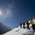
From the Elsigenalp cable car, the snowshoe trail first leads via Undere Elsige towards the snow-covered Elsigsee. After an initial ascent, there is a magnificent view of the lively centre of Elsigenalp with its ski facilities. After a gentle climb, the path leads to Obere Elsige with the Elsighütte, a traditional alpine restaurant where a stop is worthwhile. This is also the turning point of the easier Elsige Trail. The moderately difficult Elsighorn Trail continues briefly over the ski slope and then ascends steeply to the Elsighorn. You are rewarded with stunning views of the High Alps, Lake Thun and the Niesen range. Both trails return on the same route. Shortly before the cable car station, the Berghaus Elsigenalp with its sun terrace invites you to stop for a break.

Good to know
Best to visit
Directions
Elsigenalp – Berghaus Elsigenalp – Elsigsee – Elsighütte – Elsigenalp
Equipment
Snowshoes, ski poles, sturdy, high, grippy and waterproof mountain or winter hiking boots, cold and sun protection, first aid kit, food and warm drinks, mobile phone, possibly gaiters
Directions & Parking facilities
Parking at the valley station of the Elsigenalp cable car in Elsigbach
Starting and finishing point: Elsigenalp
by train to Frutigen, then by ski bus (4 times daily, only by reservation, 033 671 11 71)
Additional information
Berner Wanderwege, 031 340 01 01, info@beww.ch, bernerwanderwege.ch
License (master data)
Author´s Tip / Recommendation of the author
Variant: Elsighorn Trail
Difficulty: medium | Fitness: medium | 8.4 km | 5 h | 500 m ascent and descent
Safety guidelines
Difficulty: easy (blue) / Fitness: easy
Signage
This route is signposted as a snowshoe trail but is not specially prepared.
Avalanches
Increased avalanche danger in spring and with sudden weather changes. Helpful, but not mandatory, are an avalanche transceiver, a probe and a shovel. Check the snow conditions and possible avalanche dangers before the tour.
Behavior
Do not take unnecessary risks and respect your limits. Always stay on the signposted routes. Avoid wildlife if possible, behave quietly. Observe animals from a distance. Take your rubbish with you and leave no unwanted traces.
Map
swisstopo map: 1247 Adelboden, 1:25,000
Nearby
 ascent awaits")
