- 6:20 h
- 16.33 km
- 1,250 m
- 10 m
- 1,048 m
- 2,165 m
- 1,117 m
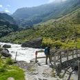
- Start: Guttannen
- Destination: Grimsel Pass
Guttannen, the largest municipality in the canton of Bern by area (200 km²), has only 8% cultivated land. As a customs and toll station, it brought some prosperity to the locals. Others earned their living as prospectors. Today, power generation from the huge water masses originating in the surrounding valleys provides secure jobs. From Postplatz, whose houses are decorated with meaningful sayings in Hasli dialect, you first cross over the Aare to the Sunnsyten district.
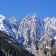
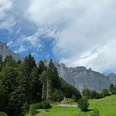
Via Tschingelmad, you reach the beautiful stone Schwarzbrunnen bridge in 1 hour and then climb past the power plant control center to the Hotel Handegg. Interesting features along the way are worth mentioning: the Saeumerstein, where packers joined in larger groups due to difficult terrain; the Haelen plates (16 steps carved into the rock and inscription of glacier researcher Agassiz), a glacial abrasion area considered the most arduous section of the Grimsel path; the photogenic stone Boeglis bridges in the hollow of Chuententennlen; the Gerstenegg crystal crevice (only viewable in combination with a guided tour of the power plants); the stone path carved into the rock along the Raeterichs Bodensee; the dams near Grimsel Hospice, from whose terrace you can enjoy a magnificent view of the fjord-like landscape of Lake Grimsel; finally, the extensive panoramic view of the Bernese, Uri and Valais High Alps from the Grimsel Pass summit, the watershed of Europe.

Good to know
Pavements
Best to visit
Directions
Guttannen - Handegg - Raeterichs Bodensee - Grimsel Hospice - Grimsel Pass
Equipment
We recommend the following equipment: sturdy mountain boots, medium-sized backpack with hip belt, sun protection, rainwear, hiking poles, first-aid kit, picnic, sufficient fluids, mobile phone.
Directions & Parking facilities
Arrival: By train to Innertkirchen. Then by bus to Guttannen.
Return: From the Grimsel Pass by bus to Innertkirchen or Gletsch.
Additional information
Association Bernese Hiking Trails, Bern, Tel.: 031 340 01 01, E-Mail: info@beww.ch, Homepage: www.bernerwanderwege.ch
Literature
Hiking suggestion from the hiking book Jungfrau Region Brienzersee - Oberhasli, hiking book series of the Bernese Hiking Trails
License (master data)
Safety guidelines
This route runs entirely or partly on marked paths of the mountain hiking trail category.
Map
Swisstopo hiking map 1:50,000 255T Susten Pass and 265T Nufenen Pass
Nearby