


- 9:00 h
- 23.24 km
- 2,000 m
- 1,800 m
- 1,170 m
- 2,690 m
- 1,520 m
- Start: Kandersteg
- Destination: Ferden
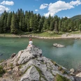
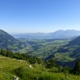
From Kandersteg station, follow the railway embankment towards the village. Through the underpass to Bütschels, then along the Kander River to Filfalle, where the railway line is crossed again. Past the valley station of the Sunnbüelbahn in Eggeschwand, uphill through the forest to the roaring Kander rushing through its rocky bed. The well-maintained path follows the wild waters along the so-called Chluse to the Waldhaus restaurant. Then you easily continue through the wide valley floor of Gastereholz. Beautiful views of the waterfalls bursting out of the rock walls below the Tatelishorn and the wild streams pouring from the Balmhorn glacier. Mostly accompanied by the rushing Kander, which meanders multibranched through its wide gravel bed, the path continues level through the botanically interesting mixed forest uphill into the valley. Below Staldi, cross the Kander, then reach Gastere/Selden on a well-maintained hillside path. In many hairpin bends it then goes steeply up to Gfelalp and over pastures and rocky steps to Balme. Magnificent view eastwards over the Kanderfirn to the Jungfrau. After that you cross the Lötschen glacier. Trail markers and poles indicate the direction to the lateral moraine, over which a distinct path runs. You also follow the trail markers over the rock nose to be climbed now (caution on the descent; children must be roped in!). The steepest part is done, and the broad hollow of the Lötschen pass offers a truly royal view of the Bernese and Valais mountains. Over rocky areas down the Stierstutz to the splendidly located Kummenalp. Then it goes 700 m steeply downhill through the Färdawald forest on the right side of the Färdanbach brook to Ferden in the Lötschental.

Good to know
Pavements
Best to visit
Directions
Kandersteg - Gastere/Selden - Lötschen Pass - Kummenalp - Ferden
Equipment
We recommend the following equipment: sturdy mountain boots, medium-sized backpack with hip belt, sun protection, rainwear, hiking poles, first aid kit, picnic, sufficient fluids, mobile phone.
Directions & Parking facilities
Outbound journey: by train to Kandersteg.
Return journey: from Ferden by bus to Goppenstein.
Additional information
Association Bernese Hiking Trails, Bern, Tel.: 031 340 01 01, E-mail: info@beww.ch, Homepage: www.bernerwanderwege.ch
Literature
Hiking suggestion from the hiking guide Thunersee - Frutigland, hiking guide series of the Bernese Hiking Trails
License (master data)
Safety guidelines
This route runs entirely or partly on mountain hiking trails.
Map
Swisstopo hiking map 1:50,000 263T Wildstrubel
Nearby