


- 5:00 h
- 16.30 km
- 337 m
- 1,400 m
- 1,104 m
- 2,063 m
- 959 m
- Start: Niederhorn
- Destination: Beatenberg
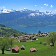
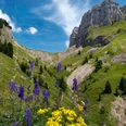
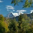
It is recommended to first hike westwards along the mountain house to the end of the ridge, as from here you can admire a magnificent view of Lake Thun, the surrounding towns, and as far as the Jura mountains. Crossing alpine pastures, you reach the Bugfeldstand, the highest point of the hike. With some luck, you may spot an eagle or the bearded vulture during its patrol flight or encounter chamois. From the Burgfeldstand to the Gemmenalphorn extends the area of ibex and snow grouse. Flower lovers will find numerous alpine flowers here. A particularly beautiful viewpoint is on the Gemmenalphorn, where the view eastwards opens up to the Sieben Hengste, the Hohgant, and the entire Seefeld area. Next follows a steep path descending from the Gemmenalphorn over the Laubenegg towards Seefeld Oberberg, past the karst area, between the cliffs down into the Justistal. On the left rises the Güggisgrat and on the right towers the Sigriswilergrat. You enter the Justistal near Hinterstberg, where a refreshment break is possible in an alpine hut. With arrangement with the herdsman, you might watch the cheese-making process. Cheese, butter, and other dairy products from this alpine farming area are available for purchase on request. The Justistal is populated with grazing cattle and between 150 and 200 deer. From mid-August during the rutting season, the roaring of the stags can be heard. Most of the path follows the stream through alpine pastures to Grön. From there, the route continues towards Beatenberg along the asphalt road. The view of the lake is wonderful, stretching from Faulensee to Thun.

Good to know
Pavements
Best to visit
Directions
Niederhorn - Burgfeldstand - Gemmenalphorn - Justistal - Beatenberg
Equipment
We recommend the following equipment: sturdy hiking boots, medium-sized backpack with hip belt, sun protection, rainwear, hiking poles, first aid kit, picnic, sufficient fluids, mobile phone.
Directions & Parking facilities
Outbound journey: by train to Interlaken West. Then by bus to Beatenberg, Niederhorn valley station. By train up to Niederhorn.
Return journey: from Beatenberg Niederhorn cable car by bus or funicular
Additional information
Bernese Hiking Trails Association, Bern, Tel.: 031 340 01 01, E-Mail: info@beww.ch, Homepage: www.bernerwanderwege.ch
License (master data)
Author´s Tip / Recommendation of the author
Safety guidelines
This route runs entirely or partly on mountain hiking trails.
Map
Swisstopo hiking map 1:50,000 254T Interlaken
Nearby

")
")