- 3:50 h
- 11.40 km
- 304 m
- 1,030 m
- 1,171 m
- 1,988 m
- 817 m
- Start: Oeschinen
- Destination: Kandersteg
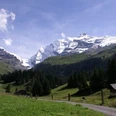
About 300 meters after leaving the mountain station towards Oeschinen Lake, keep left at the trail junction P.1670. From the alpine road, turn left at the junction P.1684 onto the white-red-white marked mountain trail towards Heuberg. Here we leave most day tourists behind and steadily ascend. The view of Oeschinen Lake becomes more and more comprehensive. At the latest at the Heuberg viewpoint (P.1940) you will inevitably take a break to admire the breathtaking panorama. The wooden benches invite you to have a picnic.
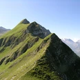
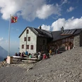
While the path has been continuously uphill until here, you now walk further with hardly any noticeable altitude differences but with a magnificent view. The high-altitude trail ends at the alpine huts Oberbärgli (where alpine cheese is sold), and we slowly descend to the right towards the mountain inn Underbärgli, which is worth a visit. Near the lake, the gently descending and well-developed hiking trail leads spectacularly along steep and partly overhanging rock walls. Keeping left, you reach the guesthouses at Oeschinen Lake at the end of the lake. Those who wish can stop here for a drink or those who still have a picnic in their backpack will find plenty of wonderful spots by the lake to enjoy the atmosphere of Oeschinen Lake one last time directly by the water. We follow the signs towards Kandersteg and thus return partly on the road, sometimes on a shortcut hiking trail, to the valley station of the cable car or to Kandersteg station.

Good to know
Pavements
Best to visit
Equipment
We recommend the following equipment: sturdy mountain boots, medium-sized backpack with hip belt, sun protection, rainwear, hiking poles, first aid kit, picnic, sufficient fluids, mobile phone.
Directions & Parking facilities
Arrival: by train to Kandersteg, on foot (15 min) or by bus to the valley station of the Oeschinen cable car
Return: by train from Kandersteg
Additional information
Association Bernese Hiking Trails, Bern, Tel.: 031 340 01 01, E-mail: info@beww.ch, Homepage: www.bernerwanderwege.ch
Literature
Hiking book Bernese Oberland of the Bernese Hiking Trails
License (master data)
Safety guidelines
This route runs completely or partially on mountain hiking trails.
Map
Swisstopo hiking map 263T Wildstrubel & 264T Jungfrau 1:50,000
Nearby