


- 4:20 h
- 11.10 km
- 605 m
- 1,060 m
- 1,306 m
- 2,134 m
- 828 m
- Start: Lombachalp-Roteschwand
- Destination: Harderkulm, Seilbahn
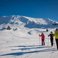
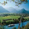
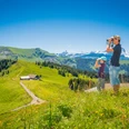
At the start of the hike at Lombachalp-Roteschwand bus stop, follow the sign for the Augstmatthorn. A path runs over grassland up to point 2101 and then to the Augstmatthorn a little further along. There are several difficult sections to overcome, however the panoramic view more than makes up for the effort. To the north, the view sweeps from the moors of Lombachalp and the source of the River Emme to the Hohgant and the Schrattenfluh. On a clear day you can even see the Jura mountains. To the east, you can make out the top of Lake Brienz and the Aare plain. The rim of the Bernese Alps can be seen spanning from the south to the west. If you’re lucky, you’ll also see a herd of ibex, proud animals that will let you watch up to just a few metres away. The next section of the hike runs a little below or over the narrow arête. This offers even more intoxicating views on the one hand, but longer exposed sections, as well as portions that are difficult to negotiate on the other. Surefootedness and a head for heights are essential. This means walking while focusing all of your attention on the path in front of you and stopping if you want to take in the view. The trickiest sections are equipped with a rope. After Suggiture, the descent takes you down below the tree line, where it continues along a varied route through meadow or woodland towards Harder. At Wannichnubel, you can take a short detour to the “Chnubel” for the view over Lake Thun. The same view can be enjoyed from the platform at Restaurant Harderkulm. An information panel will help you identify the peaks. A short distance further along you reach your destination, the summit station of the Harder Kulm funicular railway.
Please note the following rules

Good to know
Pavements
Best to visit
Directions
Roteschwand - Augstmatthorn - Roteflue - Wannichnubel – Harderkulm
Equipment
Directions & Parking facilities
Getting back: Take the funicular railway to Interlaken Ost
Additional information
Verein Berner Wanderwege, Bern, Tel.: 031 340 01 01, E-Mail: info@beww.ch, Homepage: www.bernerwanderwege.ch
Literature
Wanderbuch Panoramawanderungen der Berner Wanderwege
License (master data)
Author´s Tip / Recommendation of the author
Safety guidelines
Map
Swisstopo Wanderkarte 1:50'000 254T Interlaken
Nearby


