


- 4:45 h
- 10.09 km
- 1,400 m
- 50 m
- 1,179 m
- 2,524 m
- 1,345 m
- Start: Gsteig
- Destination: Tête aux Chamois
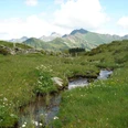
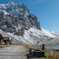
In the village center of Gsteig, a short detour to the old Hotel Bären and the noteworthy church must not be missed. Following the Rüschbach, you ascend to the Pillon Pass road, cross it, and continue along the forested riverbank. Then it goes over the pasture to the Ägerte hut. After a pleasantly cool forest hike through the Sitenwald, the path descends to the alpine buildings of Reusch (to the valley station of the Reusch-Oldenegg cable car 8 min; to Col du Pillon 1h10, –Diablerets 2h15). Ascend forestwards on the forest road. The path narrows to a trail, crosses the Oldenbach, and climbs steeply to the Büdemli alpine hut. An even steeper section must be overcome afterward, where you move westwards away from the stream and cross the battle zone of the mountain forest. On the mountain ridge above the forest, you can enjoy a magnificent panoramic view of Oldehore, Sanetsch-, Gstelli-, and Schluchhore. The massively rising rock walls around the Oldenkessel make one feel very small. You reach the intermediate station Oldenegg of the Diablerets cable cars by an almost level path (Olden circular route 1h30, mountain hiking trail). At the cable car station, zigzag uphill to the gallery under the rock walls. Behind it begins a long ascending valley trough called Entre la Reille or Martisberg. Before the construction of the gondola, this almost 3 km long, secluded high valley was rarely visited. Afterward, solitude and quietness were over. To protect the extremely rich flora, which stretches from the subalpine forest to the glaciers, a strict picking ban was imposed. The marmot colonies were also placed under nature protection. The path winds up through the high valley, crosses the canton border Bern–Vaud, and reaches the water divide at the Cabane des Diablerets. The highlight of the tour is the viewing platform Tête aux Chamois (Gemskopf; cable car station Cabane), only 40 m higher. The high Alpine peaks of the Diablerets massif are in close proximity, while to the north, the view opens towards the Vaud and Bernese Pre-Alpine peaks. The exposed descent to Col du Pillon is newly marked as an Alpine Route (caution!). The Diablerets cable car safely leads one down into the valley.

Good to know
Pavements
Best to visit
Directions
Gsteig - Reusch - Oldenegg - Cabane des Diablerets - Tête aux Chamois
Equipment
We recommend the following equipment: sturdy mountain boots, medium-sized backpack with hip belt, sun protection, rainwear, hiking poles, pocket first aid kit, picnic, sufficient fluids, mobile phone.
Directions & Parking facilities
Outbound: by train to Gstaad and then by bus to Gsteig, Post
Return: by aerial cableway from Gemskopf to Col du Pillon. From there by bus towards Gsteig/Gstaad or Les Diablerets
Additional information
Berner Wanderwege Association, Bern, Tel.: 031 340 01 01, E-mail: info@beww.ch, Homepage: www.bernerwanderwege.ch
License (master data)
Safety guidelines
This route runs wholly or partially on marked trails of the mountain hiking trail category.
Map
Swisstopo hiking map 1:50,000 263T Wildstrubel
Nearby
