


- 2:40 h
- 8.38 km
- 380 m
- 380 m
- 559 m
- 650 m
- 91 m
- Start: Oberhofen
- Destination: Merligen
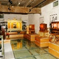
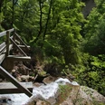
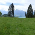
Anyone trying to classify the imposing Oberhofen Castle by its playful architecture will have a hard time: it is actually a medieval complex that was adapted in the 19th century to romantically idealized notions of the Middle Ages. Today, the castle museum, opened in 1954, serves as a branch of the Bern Historical Museum and houses an extensive display of living culture in the Canton of Bern. Nearby at the Wichterheer estate is a museum for clocks and mechanical musical instruments as well as the Im Obersteg art collection. From the landing pier next to the castle, the hiking path first leads uphill through the village, then east towards Klösterli. After crossing the Riderbach, you reach the sun-exposed vineyard of Oberhofen. In its upper part, the path continues to Längenschachen. From there, a path follows the edge of the Örtli forest close to the lake. At the Guntener village section Örtli, the next ditch flows in, which you cross with a slight ascent, before finally descending to Gunten. From Gunten, the route first heads up a paved road towards Hotel Bellevue, then continues on natural surface past farmhouses and orchards and through the forest. Along the way, idyllic views open up of the lake and the Niesen. After descending to Stampach, past vineyards, a road narrowing into a path leads to the scenic and flower-rich mountain meadow above Ralligen Castle. Through the Ralligholz and past the church, you reach the bus and boat station Merligen.

Good to know
Pavements
Best to visit
Directions
Oberhofen - Längenschachen - Örtli - Gunten - Stampbach - Ralligen - Merligen
Equipment
We recommend the following equipment: lightweight trekking shoes, light backpack, sun protection, rain jacket, pocket pharmacy, light picnic, enough fluids, mobile phone.
Directions & Parking facilities
Outbound journey: by bus or boat to Oberhofen/Dorf
Return journey: from Merligen/Beatus by boat or bus
Additional information
Bernese Hiking Trails, T 031 340 01 01, info@beww.ch, bernerwanderwege.ch
Literature
Hiking proposal from the hiking book Short Hikes, hiking book series of Bernese Hiking Trails
License (master data)
Safety guidelines
This route runs entirely on hiking paths.
Map
Swisstopo hiking map 1:50,000 253T Gantrisch and 254T Interlaken
Nearby


")
")