
- 3:45 h
- 12.12 km
- 350 m
- 380 m
- 1,054 m
- 1,358 m
- 304 m
- Start: Beatenberg/Schmocken
- Destination: Habkern
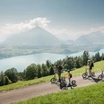
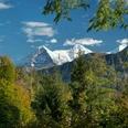
Beatenberg/Schmocken is not only a starting point for worthwhile hikes. The station of the Lake Thun-Beatenberg-Niederhorn railways is also a transport hub, as here also ends the bus route that connects the high village with Interlaken. From the railway station initially eastwards along the main road. Between Hotel Beatus and the distinctive pyramid of Hotel Dorint-Blüemlisalp, the path turns upslope and quickly leads over wooded meadows to the edge of Dälewald. Along the way, one already enjoys the magnificent view of the Bödel and the Upper Land mountain giants. The ascent continues even in the forest until point 1352, where the upper path and at the same time the highest point of the hike is reached.
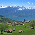
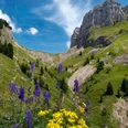
In Spirenwald, at point 1325, you stand directly beneath the massive rock bands of Bireflue. The little path gently descends into the Bödel. After thunderstorms, a wild mountain brook rages through the seemingly harmless Sundgraben, which also formed the extensive delta at Sundlauenen. At the forest edge near Waldegg, the village of Beatenberg, stretching over 6 km, can almost be seen in its entirety.
Now the landscape changes: the wooded Hardergrat stands directly opposite, and below spreads the densely populated Bödel. A narrow path leads up and down gently through the steep slope descending to the Lombach to Bort. Lonely farmhouses and numerous hedges along the way, lively mountain streams, as well as the captivating view down to the upper end of Lake Thun, ensure no boredom. On a quiet road, you reach the mountain village Habkern.

Good to know
Pavements
Best to visit
Directions
Beatenberg/Schmocken - Spirenwald - Waldegg - Bort - Habkern
Equipment
We recommend the following equipment: light trekking shoes, light backpack, sun protection, rain jacket, pocket first aid kit, light picnic, sufficient fluids, mobile phone.
Directions & Parking facilities
Outbound journey: by train to Interlaken West. Then by bus to Beatenberg/Niederhornbahn
Return journey: by bus from Habkern, Post to Interlaken West
Additional information
Bernese Hiking Trails Association, Bern, Tel.: 031 340 01 01, E-mail: info@beww.ch, Homepage: www.bernerwanderwege.ch
Literature
Hiking suggestion from the hiking book Lake Thun - Frutigland, hiking book series of the Bernese hiking trails
License (master data)
Safety guidelines
This route runs entirely on hiking trails.
Map
Swisstopo hiking map 1:50,000 254T Interlaken
Nearby


")
")
