


- 5:30 h
- 15.65 km
- 900 m
- 900 m
- 1,131 m
- 1,848 m
- 717 m
- Start: Feutersoey
- Destination: Feutersoey
From the Feutersoey post office, follow the main road towards Gsteig to the southern edge of the village. Then head uphill. In the forest begins the long, fairly steep ascent towards Hinter Walig. Initially along the forest edge, later in splendid mountain forest, you quickly gain altitude and reach the Tuxberg (via Gschwändleni–Schopfi to Gsteig 1h30), from where the view into the valley floor with many sun-tanned houses and barns around Feutersoey delights. At a similarly steep gradient, first through open forest, then over lush alpine pastures along the flank of the Hasenegg. The opposite valley side is dominated by Staldeflüe, Furggenspitz, Wittenberghorn, the distinctive rounded summit of Tête de Clé, and the Arnenhorn. At the huts of Hinter Walig, you face a choice: while the gentle descent to Arnensee (30 min) attracts some, summit climbers decide to ascend Walighürli (1h), from where magnificent views of the glaciers and peaks of the Diablerets and Sanetsch regions reward the effort of the climb. On the circular route, another 70 meters of altitude have to be overcome before a magnificent high-altitude hike begins in the battle zone of the mountain forest. The tree-covered alpine pastures allow breathtaking views down to the quiet Arnensee.
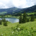
With slight ups and downs, it goes over the Blatti alpine pastures (via Blattipass to Gsteig 2h) and Ober Stuedeli. A remarkable picture of quiet mountain seclusion can be enjoyed at the huts on Alp Seeberg (via Chalet-Vieux–Lac Retaud–Col du Pillon 2h15; via Unter Stuedeli to Arnensee 30 min). In the depths lies the forest-bordered Arnensee, behind which the deep valley incision of the Tschärzisbach can be discerned; the towering Staldeflüe define the horizon. The descent to Arnensee is steep. Along the eastern shore, the trail passes the “Huus am Arnensee” before ascending to the Unter Stuedeli alpine hut. Through mountain forest, it then goes down to Linders Vorschess by the Tschärzisbach and almost level paths to Schwänd, where the quite steep descent to Feutersoey begins.

Good to know
Pavements
Best to visit
Directions
Equipment
We recommend the following equipment: sturdy mountain boots, medium-sized backpack with hip belt, sun protection, rainwear, hiking poles, small first aid kit, picnic, sufficient fluids, mobile phone.
Directions & Parking facilities
Arrival and return: By train to Gstaad. Then by bus to Feutersoey.
Additional information
Literature
Hiking suggestion from the hiking book Bernerland, hiking book series of the Berner Wanderwege
License (master data)
Safety guidelines
This route runs entirely or partly on marked trails of the mountain hiking trail category.
Map
Swisstopo hiking map 1:50,000 263T Wildstrubel
Nearby

