- 2:50 h
- 7.49 km
- 460 m
- 530 m
- 850 m
- 1,296 m
- 446 m
- Start: Suld, Suldtal
- Destination: Aeschiried, Schulhaus
This hike consists of a more strenuous and a lighter part, namely the circular route to the Pochtefall and the return through the Suldtal to Aeschiried. Until the end of September the post bus runs on weekends from Aeschiried to Suld. However, this stretch is also nice on foot – despite hard surface – so a visit to the Suldtal is worthwhile also later in autumn (an additional 1 hour 15 minutes).
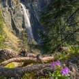
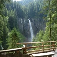
The sight of the roaring water plunging over an 80-meter-high rock face is earned from Suld on a steep circular path. Surefootedness and preferably dry weather are advantageous here. In about 20 minutes you reach a beautiful viewpoint to the waterfall. Afterwards the path becomes only slightly steeper but still climbs a good bit upwards until at the top of the Pochtenfall it crosses the bubbling stream and descends again on the other side.
From Suld it is best to first stay on the left side of the Sulbach. First through forest and over clearings, then along the brook's bank the well-developed path winds downhill through the Suldtal. After about one and a half kilometers a bridge leads to the right bank, and shortly afterwards at the wayside is a lovingly arranged picnic and barbecue place. Soon afterwards the path splits. Upwards it goes comfortably and directly back to Aeschiried. Following the brook further is the recommended, wilder, and somewhat longer route. The path soon changes banks and follows sometimes at a height, sometimes closer to the water, and occasionally also on a shaky wooden footbridge of the Suld. On the narrow path, surefootedness is again required.
At about Stächgrabe, a narrow little bridge leads back to the other bank and through dense forest uphill. Soon the sunny meadows around Aeschiried are reached again and shortly after the post bus stop.

Good to know
Pavements
Best to visit
Directions
Suld – Pochtefall – Suld – Staldeweid – Stächgrabe – Butzen – Aeschiried
Equipment
We recommend the following equipment: sturdy mountain boots, medium-sized backpack with hip belt, sun protection, rainwear, hiking poles, pocket pharmacy, picnic, sufficient fluids, mobile phone.
Directions & Parking facilities
Arrival: From Spiez train station by post bus to “Aeschiried, Schulhaus” (change) and on to Suld. Post bus to Suld runs Saturdays and Sundays from July to October.
Return: Post bus from “Aeschiried, Schulhaus” to Spiez.
Additional information
Verein Berner Wanderwege, Bern, Tel.: 031 340 01 01, E-Mail: info@beww.ch, Homepage: www.bernerwanderwege.ch
License (master data)
Safety guidelines
This route runs entirely or partly on marked trails of the mountain hiking path category.
Map
Swisstopo hiking map 254T Interlaken 1:50,000
Nearby