- 2:50 h
- 9.46 km
- 260 m
- 770 m
- 563 m
- 1,139 m
- 576 m
- Start: Habkern
- Destination: Interlaken West
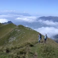
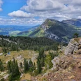
The mountain community of Habkern has a small, compact village center and extensive scattered settlement areas. From the Habkern/Post bus stop, a small road leads uphill to the Bolbach, which is crossed by an elegant reinforced concrete bridge built according to plans by the well-known designer Robert Maillart. Immediately afterwards, you cross a small covered wooden bridge and then follow a grassy path up to the road to Schwendi. From there, it goes steeply down to the Lombach and then on a narrow path on a steep mountain forest slope, just as steeply upward again to the Luegiboden. In the bed of the Lombach and at many points of the lower Habkern valley, larger and smaller granite stones with reddish-brown, olive-green, black, and white-gray inclusions can be found, which do not correspond to the granite of the Alps. They are called exotic blocks (foreign blocks) and the rock type is generally referred to as Habkern granite according to the place where it is found. The term "erratic block" is, however, incorrect because the rock was not transported here by glaciers but due to geological shifts. The largest of these granite blocks is the Luegiboden stone. Its visible dimensions are impressive: 31 x 28 x 14 m. Both the stone and its surroundings are protected: The wide, almost flat meadow at its foot – which represents the actual Luegiboden – is a moor protection area of national importance. Initially on a wide gravel path with little incline, later steeper on a narrow footpath, the route leads through the extensive forests on the northern flank of the Harder downhill to St. Niklausen. From there, you follow the edge of the forest into the small town of Unterseen and finally reach Interlaken West train station.

Good to know
Pavements
Best to visit
Directions
Habkern - Schwendi - Luegiboden - Interlaken West
Equipment
We recommend the following equipment: light trekking shoes, light backpack, sun protection, rain jacket, pocket pharmacy, light picnic, sufficient fluids, mobile phone.
Directions & Parking facilities
Journey there: by bus to Habkern, Post stop
Return journey: by train from Interlaken West
Additional information
Berner Wanderwege, T 031 340 01 01, info@beww.ch, bernerwanderwege.ch
Literature
Hiking suggestion from the short hikes hiking book, hiking book series by Berner Wanderwege
License (master data)
Safety guidelines
This route runs entirely on hiking trails.
Map
Swisstopo hiking map 1:50,000 254T Interlaken
Nearby