- 4:00 h
- 8.53 km
- 516 m
- 516 m
- 2,161 m
- 2,664 m
- 503 m
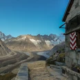
- Start: Grimsel Pass
- Destination: Grimsel Pass
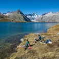
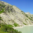
The Grimsel area is a primeval world, characterized by a rocky landscape with sparse vegetation where lichens create conspicuous accents. At the pass summit, the waters divide as they flow downstream: northwards they flow over the Aare to the Rhine and eventually the North Sea; southwards they flow into the Rhone and later into the Mediterranean. Along the watershed to the northeast runs the Nägelisgrätli, which is developed up to the Grätlisee with a well-maintained mountain hiking trail. Like other Alpine passes accessible by road, the Grimsel is a paradise for motorcyclists. Engines roar loudly on sunny summer days - a bizarre contrast to the rugged expanse of this landscape, where otherwise only power lines and the dams of hydroelectric plants bear human signs. Passing the chapel at the pass summit and the stone-enclosed viewing platform, the path steadily ascends over rocky mountain meadows to Nägelisgrätli and continues along it upward to Grätlisee. Moving southward, the scenery changes increasingly: the massive ice flow of the Rhone Glacier gradually comes into view. From Grätlisee, a detour to the Rhone Glacier viewpoint is worthwhile. This can be reached on a partly pathless route without significant elevation differences. Along the way, fields of rubble and massive blocks of stone are crossed, beneath which mountain streams flow unseen but loudly babbling downstream. The return over Grätlisee to Grimsel is on the same route.

Good to know
Pavements
Best to visit
Directions
Equipment
Directions & Parking facilities
Outbound and return travel: by bus from Innertkirchen, Grimseltor to Grimsel Pass summit
Additional information
License (master data)
Safety guidelines
Map
Nearby