- 4:10 h
- 11.22 km
- 400 m
- 930 m
- 1,171 m
- 1,988 m
- 817 m
- Start: Kandersteg
- Destination: Kandersteg
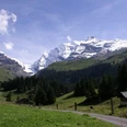
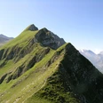
From Kandersteg station into the village center. At the church, a few steps downhill, then it turns again towards the all-dominant Blüemlisalp. After crossing the Öschibach, near the valley station of the gondola, the steep ascent begins through the sunny slope to the Alp Oeschinen (20 min to Lake Oeschinen). Here, the path leading from the mountain station also joins. At point 1685, above the houses in the Läger (10 min to Lake Oeschinen), begins probably the most beautiful section of the circular hike. Even locals praise the magnificent high trail, which first passes through mountain forest and then runs directly above the cliffs that fall steeply to Lake Oeschinen. At Heuberg, you have the deep blue mountain lake almost vertically at your feet. On an almost level path, you now reach Oberbärgli between the rock bands. The view of the Blüemlisalp group and towards Oeschinen, Fründen, and Doldenhorn and their glaciers is unique. Also of wild beauty is the steep descent over alpine meadows and through rock bands to Underbärgli and to the shores of the world-famous Lake Oeschinen. From the glaciers, the water falls foaming and roaring into the 60 m deep mountain lake. It was formed by a rockfall from the Doldenhorn. The debris masses dammed up its waters. Its outflow is underground. The water emerges again 500 m further downstream as the Öschibach. Following the Öschibach, you continue the descent and soon reach the starting point in Kandersteg again.

Good to know
Pavements
Best to visit
Directions
Kandersteg - Heuberg - Oberbärgli - Lake Oeschinen - Kandersteg
Equipment
We recommend the following equipment: sturdy hiking boots, medium-sized backpack with hip belt, sun protection, rainwear, hiking poles, pocket first aid kit, packed lunch, sufficient fluids, mobile phone.
Additional information
Bernese Hiking Trails Association, Bern, Tel.: 031 340 01 01, Email: info@beww.ch, Homepage: www.bernerwanderwege.ch
Literature
Hiking suggestion from the hiking book Bernerland, hiking book series of the Bernese Hiking Trails
License (master data)
Safety guidelines
This route runs entirely or partly on mountain hiking trails.
Map
Swisstopo hiking map 1:50,000 264T Jungfrau
Nearby