


- 3:30 h
- 10.25 km
- 147 m
- 1,380 m
- 1,329 m
- 2,524 m
- 1,195 m
- Start: Tête aux Chamois
- Destination: Reusch
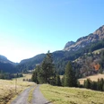
From the middle station Tête aux Chamois, you are in just five minutes at the Cabane des Diablerets. From here the descent towards Oldenegg into the Martisberg valley depression begins. What is a ski slope in winter (which can be easily recognized by the lift masts) is decorated in summer with numerous alpine flowers such as blue monkshood, purple gentian, or magnificent silver thistles. The Schluchhore prominently towers over the other side of the valley in the lower part of Martisberg. Shortly before Oldenegg, the path leads through a gallery – the section before the gallery should be passed quickly due to the danger of falling rocks.
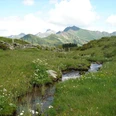
At the Oldenegg mountain station, you can take the cable car directly to Reusch. Those who still want to hike the impressive Olde valley basin follow the signposted "Olden – Large Circular Route." After a short climb, the hiking trail makes a right turn and then leads without significant altitude changes above the valley floor in a large left curve around the valley basin. At the alpine huts of the lower Oldenalp, the Oldebach is crossed. If you keep left, you close the circular route 25 minutes later at the Oldenegg mountain station. If you branch right towards Reusch, you save the cable car ride and descend another 500 vertical meters through the Büdemli basin to the Reusch valley station. The beautiful section near the waterfall at P.1792 is quite steep and requires some concentration.

Good to know
Pavements
Best to visit
Directions
Equipment
Directions & Parking facilities
Outbound: by bus from Gstaad to Col du Pillon
Return: by bus from Reusch valley station stop to Gstaad train station
Additional information
Literature
Hiking book Bernese Oberland by Berner Wanderwege
License (master data)
Safety guidelines
Map
Swisstopo hiking map: 5025T Saanenland Simmental
Nearby
