


- 4:00 h
- 14.58 km
- 410 m
- 410 m
- 558 m
- 789 m
- 231 m
- Start: Spiez/boat station
- Destination: Spiez/boat station
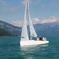
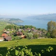
The circular hike around Spiez can be started or ended at various points thanks to good transport connections. An ideal starting point is the boat landing below the castle. Those arriving by train instead of by boat reach the bay from the station in about a fifteen-minute walk or by bus. Passing the outdoor swimming pool, you reach the beach path, an idyllic lakeside path that runs directly along Lake Thun to Faulensee. From there, you ascend on small paved roads. After passing under the railway line and motorway, you reach the Seeholzwald forest, which you cross while continuing to ascend on gravel paths. At the forest edge, the impressive pyramid of the Niesen suddenly comes into view. The farming village of Hondrich, home to a training center for mountain agriculture and home economics, exudes a distinctly alpine charm. With a beautiful view into the Niedersimmental valley, you descend over meadows and through woods to Spiezwiler, pass through the village on sidewalks and neighborhood streets, and hike above the retention pond to Lattigen, where the route turns eastward. After crossing the Spiezmoos district, you reach the wooded Spiezberg and continue past the extensive vineyard down to Spiez Castle and back to the starting point at the boat landing in Spiez Bay. A brochure is available for the Spiez circular hiking trail, which can be obtained from the tourism office at the station or downloaded from the website spiez.ch. It offers detailed information about various sights along the route that are protected as natural or cultural monuments.

Good to know
Pavements
Best to visit
Directions
Spiez/Bay - Faulensee - Hondrich - Spiezwiler - Lattigen - Spiezmoos - Spiezberg - Spiez/Bay
Equipment
We recommend the following equipment: lightweight trekking shoes, light backpack, sun protection, rain jacket, small first aid kit, light picnic, sufficient fluids, mobile phone.
Directions & Parking facilities
Additional information
Bernese hiking trails, T 031 340 01 01, info@beww.ch, bernerwanderwege.ch
Literature
Hiking book short hikes 2 of the Bernese hiking trails
License (master data)
Safety guidelines
This route runs exclusively on marked paths of the hiking trail category
Map
Swisstopo hiking map 253T Gantrisch 1:50,000
Nearby


")
