- 2:30 h
- 8.24 km
- 1 m
- 919 m
- 1,039 m
- 1,958 m
- 919 m
- Start: Grosse Scheidegg
- Destination: Grindelwald
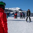
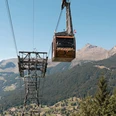
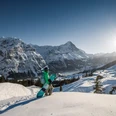
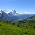
Hardly anywhere else can the transition from forested valleys over wide alpine meadows to rock, ice, and snow be experienced so vividly. The almost vertical wall of the Wetterhorn rises steeply. The view over Grindelwald to Kleine Scheidegg is open, next to which the famous and notorious north face of the Eiger towers. For the descent into the glacier village, choose the old, well-preserved mule track that crosses the modern mountain pass road several times. At Undren Loichbiel, turn downhill onto the access path to the upper Grindelwald Glacier. About 600 m of descent remain from Lamm to the densely settled valley floor of Grindelwald. The bird's-eye view is perfect. Unfortunately, nothing of the glaciers shaping the village is visible. During the great glacier advance around 1760, the ice streams rolled so deep into the valley that their tongues reached into the forest. The subsequent mountain enthusiasm finally led to the development of the natural wonders by mountain railways. However, not all were successful. Near the Wetterhorn Hotel still stands a cabin of the former Wetterhorn lift from 1908, the world's first cable car. Due to lack of capital and damage by a rockfall, the company was already ended early in 1934. Via Underhüseren, you reach the long road village of Grindelwald.

Good to know
Pavements
Best to visit
Directions
Grosse Scheidegg - in the lower Loichbüel - upper glaciers - Grindelwald
Equipment
We recommend the following equipment: sturdy mountain boots, medium-sized backpack with hip belt, sun protection, rainwear, hiking poles, first aid kit, picnic, sufficient fluids.
Additional information
Association of Bernese Hiking Trails, Bern, Tel.: 031 340 01 01, E-mail: info@beww.ch, homepage: www.bernerwanderwege.ch
Literature
Hiking suggestion from the hiking book Passwege in the Bernese Oberland, hiking book series of the BWW
License (master data)
Safety guidelines
This route runs wholly or partly on marked trails of the mountain hiking trail category
Map
Swisstopo hiking map 1:50,000 254T Interlaken
Nearby