- 2:35 h
- 7.31 km
- 400 m
- 400 m
- 1,213 m
- 1,463 m
- 250 m
- Start: Grindelwald/Weidli
- Destination: Grindelwald/Oberer Gletscher
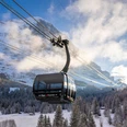
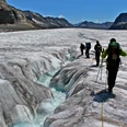
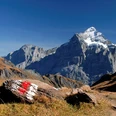
The starting point of the hike can be reached from Grindelwald by bus towards Bussalp. From the Weidli/Abbachfall stop, first follow the road uphill. On a wide forest road, go slightly downhill to the junction with the Grindelwald–Holewang hiking trail, then steeply uphill to the edge of the forest and to the restaurant at Ällflüü (35 min from Grindelwald). The view across the valley here is splendid. The following forest hike ends just above the former intermediate station Oberhaus of the Grindelwald-First-Bahn (30 min from Grindelwald). Without significant altitude difference, the path, later a small road, runs through the sunny slope, crosses the Milibach and the Horbach streams, and descends to the houses in Moos. Along the way, you have magnificent views of the Mättenberg, the Wetterhorn, the Upper Grindelwald Glacier, and the Grosse Scheidegg. Over the Bärgelbach, you finally reach Schopfweid on Scheideggstrasse and cross this to the Hotel Wetterhorn at the entrance to the Upper Grindelwald Glacier.

Good to know
Pavements
Best to visit
Directions
Grindelwald/Abbachfall - Ällflüü - Grindelwald/Oberer Gletscher
Equipment
We recommend the following equipment: Light trekking shoes, light backpack, sun protection, rain jacket, first aid kit, light picnic, sufficient fluids, mobile phone.
Directions & Parking facilities
Outbound journey: by train to Grindelwald. Then by bus to Grindelwald/Weidli (Busalp line or Waldspitz)
Return journey: by bus from Oberer Gletscher to Grindelwald station
Additional information
Berner Wanderwege association, Bern, Tel.: 031 340 01 01, Email: info@beww.ch, homepage: www.bernerwanderwege.ch
Literature
Hiking suggestion from the hiking book Jungfrau Region Brienz Lake - Oberhasli, hiking book series of the Berner Wanderwege.
License (master data)
Safety guidelines
This route runs exclusively on marked paths in the category hiking trail.
Map
Swisstopo hiking map 1:50,000 254T Interlaken,
Nearby